Sunday, May 31, 2015

Art Deco Miami Beach: 1001 to 1224 Ocean Drive

Historic Art Deco District 
Miami Beach, FL


Beach Patrol Headquarters
GPS: N 25° 46.815 W 080° 07.798
Address: 1001 Ocean Drive
Architect: Robert Taylor
Built: 1934 


Clevelander Hotel
GPS: N 25° 46.850 W 080° 07.843
Address: 1020 Ocean Drive 
Architect: Albert Anis
Built: 1938


Congress Hotel
GPS: N 25° 46.868 W 080° 07.836
Address: 1052 Ocean Drive
Architect: Henry Hohauser
Built: 1934 


Tides Hotel
GPS: N 25° 46.980 W 080° 07.813
Address: 1220 Ocean Drive 
Architect: Lawrence Murray Dixon
Built: 1936


Leslie Hotel
GPS: N 25° 47.009 W 080° 07.804
Address: 1244 Ocean Drive 
Architect: Albert Anis 
Built: 1937

Saturday, May 30, 2015

Art Deco Miami Beach: 140 to 960 Ocean Drive

Historic Art Deco District
Miami Beach, FL


Century Hotel 
GPS: N 25° 46.225 W 080° 07.978
Address: 140 Ocean Drive
Architect: Henry Hohauser
Built: 1938


Savoy Hotel
GPS: N 25° 46.427 W 080° 07.923
Address: 140 Ocean Drive
Architecst: V.M. Neillenbogen & Albert Anis
Built: 1935


Park Central Hotel
GPS: N 25° 46.581 W 080° 07.902
Address: 640 Ocean Drive
Architect: Henry Hohauser
Built: 1937


Edison Hotel
GPS: N 25° 46.818 W 080° 07.847
Address: 960 Ocean Drive
Architect: Henry Hohauser
Built: 1935

Friday, May 29, 2015

Puntarenas, Costa Rica: Catedral Nuestra Señora del Carmen

Catedral Nuestra Señora del Carmen
Puntarenas, Costa Rica


N 09° 58.661 W 084° 50.078


Short Description: 

The Catedral Nuestra Señora del Carmen (Cathedral of Our Lady of Mount Carmel) is located in Parque Central de Puntarenas north of Central Avenue and east of Calle 7 in the center of Puntarenas.

Long Description:


In 1901, a new church was commissioned in Puntarenas to replace a previous structure that was destroyed by fire. The resulting neo-Gothic church, Nuestra Señora del Carmen (Our Lady of Mount Carmel) is constructed of brown stone held together by white mortar. The west facing entrance is a three story structure containing a pyramidal roof topped with a small white cross. Below is a clock tower with containing clocks on all four sides. Below the clock is a single arched window. On the second level are a pair of arched windows. The entrance is flanked with a pair wings each containing a single window on the west side.


In 1998, Puntarenas became a diocese in the archdiocese of San José de Costa Rica and the church became a cathedral. The first bishop was Hugo Barrantes Ureña who was appointed on April 17, 1998. The current residing bishop is Oscar Gerardo Fernández Guillén who was appointed on June 4, 2003.

The stamp was issued by Costa Rica in 2008 as part of a sheet of six stamps depicting churches of Costa Rica.

Thursday, May 28, 2015

Puntarenas, Costa Rica: Monument to the Muellero (Dock Workers)

Monument to the Muellero (Dock Workers)
Puntarenas, Costa Rica


N 09° 58.527 W 084° 49.855

Short Description: 

Monument to the Muellero is located at Avenue 4 and Street 0 at the end of the large ship dock in Puntarenas, Costa Rica.

Long Description:

Monument to the Muellero is a 5.64' tall bronze sculpture of a dock worker by Costa Rican artist Luis Francisco Ortega Brenes, who has several other sculptures throughout Puntarenas. The sculpture stands on an unadorned 6' square base that tapers up to a 3' square platform supporting the sculpture.


The bare-chested dock worker is wearing boots and pants and carrying a large sack on his right shoulder. He is leaning slightly forward and supporting the sack with his right arm in front of the sack while is left arm is by his side. The left leg of the sculpture is dated 1993 and the right leg carries the name of the sculptor BRENES.

Although there is no plaque identifying the purpose of the sculpture the official Costa Rica Tourism website gives the following information:

Wednesday, May 27, 2015

Puntarenas, Costa Rica: Cruise Ship Port

Puntarenas Cruise Ship Port
Puntarenas, Costa Rica


N 09° 58.505 W 084° 49.890

Short Description: 

The Puntarenas Cruise Ship Port is located on the south shore of Puntarenas at Avenue 4 and Calle 0

Long Description:


In Puntarenas the even numbered streets are east of the pier and the odd numbered streets are to the west. The cruise ship pier is the demarcation point. Puntarenas (Port of Sand) is a long peninsular jutting out into the Gulf of Nicoya on the Pacific Ocean side of Costa Rica. It is becoming popular as a cruise ship port due to its central location, proximity to San Jose, and sand beaches that line the peninsula.

The original pier in this location was installed in 1929. The present reinforced concrete pier with metal railing was constructed in 1998, with donations from the Taiwanese Government, at a cost of $15.000.000. The tourist season runs from May to October when Puntarenas is visited by many thousands of tourists from the cruise ships.

The pier was declared an architectural historic heritage on October 25, 1994. In April 2008, the Costa Rica Tourism Board re-dedicated the pier as a tourism service center under the project “Puntarenas por siempre” (Punatarenas Forever).

The pier is over 200' long. At the end of the pier to the east is the Paseo de los Turistas which has restaurants, as well as many craft and souvenir kiosks set up when ships are in port. Excursion buses meet the ship at the pier.


Tuesday, May 26, 2015

Inglesia de Nuestra Señora de Guadalupe: La Crucecita, Oaxaca, Mexico

Art at 
Inglesia de Nuestra Señora de Guadalupe
La Crucecita, Oaxaca, Mexico

Inglesia de Nuestra Señora de Guadalupe
N 15° 45.895 W 096° 08.346

Short  Description: 

A ceiling mural of the patron saint of Mexico, Our Lady of Guadalupe and a mosaic of Our Lady of Perpetual Help is located in Inglesia de Nuestra Señora de Guadalupe, commonly known as La Crucecita Church, in the center of La Crucecita, Oaxaca, Mexico.

Long Description:


Our Lady of Guadalupe


This huge ceiling mural of Our Lady of Guadalupe extends from the street entrance of the church on the east to above the altar at the opposite, west, end of the church. The mural is the major attraction of La Crucecita and one of the most visited attractions of the Huatulco region of Mexico.

The mural was painted by Mexican artist Jose del Signo and is about 30 meters long (92') and 285 meters square (881 sq. ft.) in area. It is the largest painting of the Virgin Mary in Mexico. The mural was painted before the dedication of the church which occurred in 2000.

Mosaic
Original Icon
Our Lady of Perpetual Help is a title for the Blessed Virgin Mary as depicted in a well known 15th-century Byzantine icon at the church of Sant'Alfonso di Liguori in Rome, Italy. An exact mosaic copy of this famous icon is located in the Church of Our Lady of Guadalupe in the small town of La Crucecita, Mexico.

The image is set against a gold background and depicts the Blessed Virgin Mary wearing dark red dress with a blue mantle and cloaked veil. Mary looking forward while holding the hands of her son, Jesus. Characteristically the left sandal of Jesus is shown falling from his foot. The two angels in the background are Michael, on the left, and Gabriel, on the right. The mosaic is located in an alcove known as the Chapel of Our Lady of Perpetual Help (Capilla De Nuestra Señora del Perpetuo Socorro).

Monday, May 25, 2015

Waterloo, NY: Birthplace of Memorial Day

Memorial Day
 Historical Marker and Monument
Waterloo, NY


N 42° 54.259 W 076° 52.021

Short Description: 

A New York State historical marker describing the history of Memorial Day is located on Rts. 5 and 20 in Waterloo, NY

Long Description:

An historical marker erected by the State Education Department is inscribed:

Historic New York

Memorial Day

On May 5, 1866, the residents of Waterloo held the first complete, community-wide observance of Memorial Day. They dedicated the entire day to honoring the Civil War dead in a solemn and patriotic manner. Throughout the village, flags, draped in mourning, flew at half mast. Ladies prepared wreaths and bouquets for each veteran's grave. Businesses closed, and veterans, civil organizations and townspeople marched to the strains of martial music to the village cemeteries. There, with reverent prayers and patriotic ceremonies, the tradition of Memorial Day was born.

Henry C. Welles, a prominent citizen, first proposed the idea for a day completely devoted to honoring the Civil War dead. General John B. Murray, the Seneca County Clerk, who had commanded the 148th New York Infantry Regiment in the war, quicky advanced the thought and marshalled community support. Since that year, Waterloo has annually observed Memorial Day. New York, in 1873, became the first state to proclaim Memorial Day, or Decoration Day, as it was originally called, a public holiday.

In May 1966, a joint resolution by the United States Congress and a proclamation by President Lyndon B. Johnson officially recognized Waterloo as the birthplace of Memorial Day.


The State Education Department

A nearby monument celebrates Waterloo New York as the Birthplace of Memorial Day in 1866


Sunday, May 24, 2015

Tour of the Bays of Huatulco: Oaxaca, Mexico


Bays of Huatulco
Oaxaca, Mexico


N 15° 45.265 W 096° 07.897

Short Description:

The Bays of Huatulco (Bahias de Huatulco) are a series of nine bays and numerous small coves stretching along 16 miles of jagged coastline. In the center is the Bay of Santa Cruz where the boat tour begins.

Long Description:

The boat tour leaves the harbor at Santa Cruz and takes visitors first east and then west along the bays. Along the way their are views of the rugged shoreline:


On top of highest point of land is the Huatulco Lighthouse:


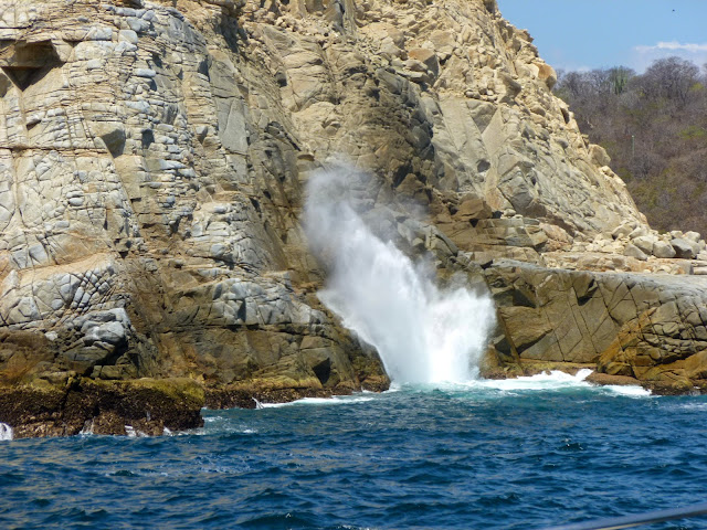
A blowhole performs for visitors below the lighthouse: A blowhole forms when a sea cave erodes upward until if finally brakes through the surface.   Waves force water into the sea side opening and the water shoots out from the top like a geyser.


At the western most point of the tour, there is an uncanny sight. A rock formations near the shore clearly resembles a human face, complete with brow, eyes, nose, and mouth. He seems to be resting with his face propped against and adjacent rock. There is no land access to the Cara de Piedra, it can only be viewed by boat from the bay.


N 15° 43.726 W 096° 08.664

Friday, May 22, 2015

Vitrofusion Glass Blowing Factory - Cabo San Lucas, Baja California Sur, Mexico

Vitrofusion Glass Blowing Factory
Cabo San Lucas
Baja California Sur, Mexico


N 22° 53.900 W 109° 54.583

Quick Description: 

The Vitrofusion Glass Blowing Factory is located in an industrial area at Lazaro Cardenas S/N Edificio Posada Local 6-A, Cabo San Lucas, Baja California Sur, Mexico.

Long Description:

The Vitrofusion Glass Blowing Factory is one of the top tourist and shopping attractions in Cabo San Lucas. Sebastian Romo opened a glass blowing factory in 1990 that converts recycled glass into blown glass works of art. The factory employs over 30 artisans that produce over 500 distinctive blown glass pieces. The exterior factory building is decorated with many stained glass windows depicting the glass blowing process and local themes.


Visitors view the process from a seating in front of the furnace. You watch as recycled waste glass is remelted and then hand blown by a team of glass blowing artisans into useful and decorative items. Workers perform for the public daily from 9 am to 2 pm. Items produced by the artisans are on display and are for sale in the adjacent gift shop.


Painted on the wall opposite the viewing gallery is 10' by 14' mural depicting the glass blowing process. The mural depicts a glass melting furnace and artisans working glass. Pictures of decorative and practical pieces of blown glass are scattered throughout the mural. The mural was produced in 1996 and signed by by two artists Leóne and G. Ozun.


The Vitrofusion Glass Blowing Factory is open to the public daily from 10 am to 5 pm. Glass blowing artisans are plying their art until 2 pm.

Thursday, May 21, 2015

Land's End - Cabo San Lucas, Baja California Sur, Mexico

A Trip Along Land's End
Cabo San Lucas 
Baja California Sur, Mexico


N 22° 52.606 W 109° 53.653
El Arco

Short Description: 

Lover's Beach, Map Rock (Neptune's Finger), El Arco, Pirate Cave, and Divorce Beach are the main site you will see as you travel by boat along Land's End.

Long Description:

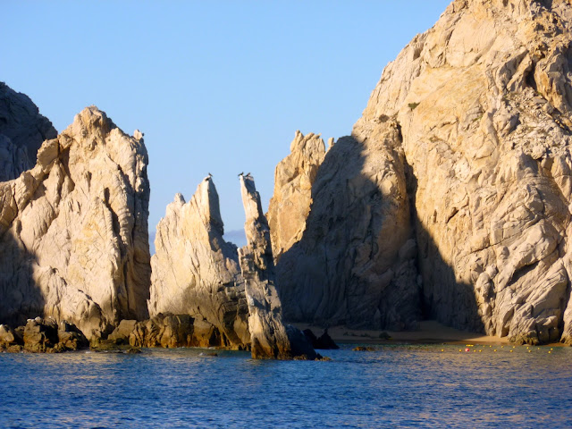
For a small charge numerous water taxis will take you from the harbor of Cabo San Lucas south along the Baja Peninsula in a region known as Land's End.   Along the way you will see several famous landmarks such as: Lover's beach, Divorce Beach, Map Rock, and Pirates Cove. The most spectacular sight is the at the very tip of the rocky peninsula where the Sea of Cortez meets the Pacific Ocean. There ocean currents and the winds have carved a natural arch that juts out into the sea. This iconic landmark has become the widely recognized symbol of the area.


Lover's Beach is a popular swimming location on the Sea of Cortez. The gap in the rocky hills connects it to Divorce Beach.


Map rock, a.k.a. Neptune's Finger is an upright rock that resembles an inverted map of Baja California.


El Arco (The Arch) is an iconic 200' foot high granite rock arch situated at the tip of the the Baja California peninsula formed by the erosive action of waves and wind.


Pirates Cave is a sea cave caused by the pounding of waves. It a popular rendevous spot for couples. A place where two people enter the cave and three people emerge.


Divorce Beach is on the Pacific Ocean side of Land's End. The currents are so dangerous that swimming is forbidden.


Whales are often seen around in the waters around Land's End