Saturday, January 19, 2013

1000 Places to See Before You Die: Alberobello - Apuglia, Italy


Alberobello
Apuglia, Italy
Topic: 1000 Places to See Before You Die

San Antonio Church
Trulli Buildings

GPS: N40° 46.868;  E017° 14.076

Quick Description: 

Alberobello is renown because of the distinctive architecture of its trulli buildings.

Long Description:

The technique for constructing a trullo dates back to pre-historic times. Limestone blocks are laid on top of each other, without the use of mortar, to enclose a circle. The building is topped by a dome-shaped roof made of gray limestone slabs. The roof is often marked with a magical or pagan symbol and capped with a decorative pinnacle.

At Alberobello these brilliant white trulli beehive structures, which are found nowhere else in the country, line the narrow streets and are occupied by residents and small businesses. The trullo church of San Antonio is the largest structure in the area and sits on a hilltop above the homes and businesses.

Name of Source Book:
1000 Places to See Before You Die
Page Location in Source Book: 181
Type of Waymark: Town
Location of Coordinates: Church of San Antonio

Friday, January 18, 2013

Mural: History Of Women in Northampton, MA


History Of Women in Northampton From 1600 To 1980 
Northampton, MA

Topic: Mural


GPS: N42° 19.107; W072° 37.979

Quick Description: 

A 3216 square foot mural depicts the history of women, both known and unknown, in Northampton from 1600 to 1980.

Long Description:

The Hestia Art Collective of five local artist created this huge mural in downtown Northampton. It depicts women of all walks of life who made a contribution to the history of Northampton. The figure on the left is Susanne Lathrop, a painter who along with her sisters opened a studio called the Northampton Salon in 1886. On the extreme right is Sojourner Truth an abolitionist and women's rights activist. In between are women from the past, both known and unknown.

The original mural was created in 1980 and updated in 2003 to include six contemporary women. Peace activist Frances Crowe, former Northampton Mayor Mary Ford, current Mayor Clare Higgins, domestic violence activist Yoko Kato, coach Agnes "Gush" Valenta, former Smith College President Ruth Simmons, and Jessie Benoit, a friend to the homeless and needy.

The collective was named after the Greek goddess Hestia, the keeper of the eternal flame. The group included and included Linda Bond, Mariah Fee, Susan Pontious, Rochelle Schieff, and Wednesday
Sorokin.

City: Northampton
Location Name: Verizon Building - 61 Masonic Street
Artist: Linda Bond, Mariah Fee, Susan Pontious, Rochelle Schieff, and Wednesday
Date: 2003
Media: paint on brick

Thursday, January 17, 2013

Civil Rights Memorial: Anne Sullivan & Helen Keller - Feeding Hills, MA


Interesting Places I've Photographed
Anne Sullivan and Helen Keller Monument
Feeding Hills, MA
Topic: Civil Rights Memorial


GPS: N42° 04.001; W072° 40.684

Quick Description: 
This monument is the second copy of the Mico Kaufman statue. It is located at the southeast corner of Springfield St. (Route 147) and South Westfield St. (Route 187) in Agawam, a short distance from where Anne Sullivan was born. 

Note: The names of Anne Sullivan and Helen Keller are not found at the memorial.

Long Description:

Anne Sullivan (1866-1936) was born on April 14, 1866 in Feeding Hills, Massachusetts. Anne, who was nearly blind from an untreated eye infection, became a student at the Perkins School for the Blind in Boston. The director of the Institute recommended her to the Keller family as a teacher for the young deafblind Helen Keller (1880-1968).

Anne Sullivan's strategy was to teach Helen to communicate by spelling words into her hand. After many unsuccessful attempts Helen finally realized that the motions Anne made in her hand, while running water over her other hand, meant "water". This moment of insight is captured in the sculpture.

Helen went on to become the first deafblind person to earn a Bachelor of Arts degree and became a prolific author, lecturer and social activist. Anne and Helen became lifelong companions and collaborators. Their story is recounted in the 1962 Academy Award winning movie "The Miracle Worker".

Helen's image appears on the Alabama state quarter and her statue is on display at the U.S. Capitol.

This sculpture captures the moment Anne Sullivan successfully teaches Helen Keller her first word - "WATER". It is the creation of the Romanian-American sculptor Mico Kaufman and was dedicated on June 28, 1992.

Civil Right Type: Disability

Wednesday, January 16, 2013

Civil Rights Memorial: Anne Sullivan & Helen Keller - Tewksbury, MA


Interesting Places I've Photographed
Anne Sullivan and Helen Keller Memorial
Tewksbury, MA
Topic: Civil Rights Memorial


GPS: N42° 36.723; W071° 14.043

Quick Description: 

This sculpture captures the moment Anne Sullivan successfully teaches Helen Keller her first word - water.

Long Description:

Anne Sullivan (1866-1936) was born on April 14, 1866 in Feeding Hills, Massachusetts. Early in her life she was a resident of the Tewksbury Alms House, now the Tewksbury Hospital. Anne, who was nearly blind from an untreated eye infection, then became a student at the Perkins School for the Blind in Boston. The director of the Institute recommended her to the Keller family as a teacher for the young deafblind Helen Keller (1880-1968) from Tuscumbia, Alabama.

Anne Sullivan's strategy was to teach Helen to communicate by spelling words into her hand. After many unsuccessful attempts Helen finally realized that the motions Anne made in her hand, while running water over her other hand, meant "water". This moment of insight is captured in the sculpture.

Helen went on to become the first deafblind person to earn a Bachelor of Arts degree and became a prolific author, lecturer and social activist. Anne and Helen became lifelong companions and collaborators. Their story is recounted in the 1962 Academy Award winning movie "The Miracle Worker".

The sculpture "Water" is located on the north side of the town hall in Tewksbury, MA. Both Anne Sullivan and young Helen Keller are sitting on the ground with their knees upright. Both are wearing long dresses. Anne's left hand is making the sign for "water" into Helen's right hand while Helen faces the sky.

"Water" is the creation of the Romanian-American sculptor Mico Kaufman. The rough bronze sculpture is 44" high by 5' 9" long. It rests on a polished granite base which is 1' by 8' 1" in. by 4' 5". On the base is inscribed: ANNE SULLIVAN, TEACHER AND HELEN KELLER. A small bronze plaque on the base gives the title "WATER" and the name of the artist MICO KAUFMAN SC. and the date 1985, the year the sculpture was created and dedicated.

The sculpture was a gift, from local citizens to the town of Tewksbury, commemorating the 250th anniversary of the incorporation of the town in 1764. A nearby plaque is inscribed:

ANNE SULLIVAN AND HELEN KELLER MEMORIAL SCULPTURE

COMMEMORATING THE 250TH ANNIVERSARY OF TEWKSBURY


MAJOR CONTRIBUTERS
followed by 24 double column rows of names.

Civil Right Type: Disability

Tuesday, January 15, 2013

NRHP: Masonic Temple - Springfield, MA


Interesting Places I've Photographed
Masonic Temple
Springfield, MA
Topic: National Register of Historic Places


N 42° 06.343 W 072° 34.843

Quick Description: 

The former home of the Esoteric-Sherwood Lodge, A.F. & A.M., District #29, in Springfield, MA. It is one of the most impressive structures in Springfield and listed on the U.S. National Register of Historic Places.

Long Description:

The Springfield Masonic Temple is located at 339-341 State Street. The cornerstone for the building was laid in 1924. It was completed in 1926 at a cost of $1,000,000, and is one of the most impressive buildings found in Springfield. It is 116 feet long, 180 feet deep and 102 feet high.

The Masonic Temple's neo-classical style exterior is monumental. It is built of Indiana limestone with terra cotta trim. The front has symbols and Egyptian detailing characteristic of Masonry.

The main entrance is centrally located and reached by two flights of stairs. Above the door is a two-storey colonnade of four columns that are meant to be replicas of a late Egyptian temple. The central ornament behind the colonnade is a large panel with the square and compass, gold triangle ,Maltese Cross, and an Assyrian double eagle. A frieze over the colonnade has three panels. The side panels are inscribed: A.L. 5924 and A.D. 1924. The central panel has a the Latin words: "Aedificatum Ut Lux Splendesceret" ("Erected That Light Might Become Brighter").

The Esoteric-Sherwood Lodge, A.F. & A.M., sold the building for use as a church - The Basilica Of The Holy Apostle. It is now once again vacant and for sale.

Street address:

339-341 State Street
Springfield, MA United States
01103

Monday, January 14, 2013

Philatelic Photograph: Skógafoss - Skógar, Iceland


Interesting Places I've Photographed
Skógafoss
Skógar, Iceland
Topic: Philatelic Photograph


GPS: N63° 31.909; W019° 30.731

Quick Description: 

Skógafoss is located in the south part of Iceland near the settlement of Skógar.

Long Description:

Skógafoss is a glacier fed waterfall that tumbles over a series of cliffs that form formed the southern coastline of Iceland. The sea receded and now the cliffs are about 3 miles inland from the sea. Skógafoss is one of the largest of Iceland's waterfalls. The waterfall is south of the Eyjafjallajökull Volcano Glacier and the huge Myrdalsjokull Glacier. The rim of the waterfall is 82 feet wide and the fall has a vertical drop of 200 feet.

Depending on the extent of the water flow, you can get very close to the base of the waterfall. A trail lead to a flat area that surrounds the pool formed by Skógafoss. A hiking trail on the east side will allow access to the area behind the falls and then over the falls to the glaciers to the north.

The stamp was issued by Iceland in 1956 as part of a set of eight stamps featuring Icelandic waterfalls.

Stamp Issuing Country: Iceland
Date of Issue: April 4, 1956
Denomination: 15 Aurar
Color: violet blue

Sunday, January 13, 2013

Sculpture Garden: Vigeland Sculpture Garden - Oslo, Norway


Interesting Places I've Photographed
Vigeland Sculpture Garden
Oslo, Norway
Topic: Sculpture Garden
Monolith

Children
Stairway Grouping


Fountain

Angry Boy
GPS: N59° 55.495; E010° 42.438

Quick Description: 

The Vigeland Sculpture Garden is located in Frogner Park, a large public park northwest of downtown Oslo.

Long Description:

Be prepared to be totally amazed. The Vigeland Sculpture Garden was created by Gustav Vigeland. It contains 212 works of art carved out of granite and cast in bronze and iron. The Vigeland Sculpture Park was constructed between between 1939 and 1949.

Sculptures are placed in five sections along an 850 meter long path on the side of a hill. From bottom to top they are: the Main Gate, the Bridge with the Children's playground, the Fountain, the Monolith plateau and the Wheel of Life.

On our tour of Oslo, we were wisely transported to the top of the hill and walked downhill through the sculpture garden. The sculptures are similar in theme and unlike any thing I've ever seen before. The theme of the sculptures is the journey through life and the struggle to become closer with the spiritual and divine. Human figures are all depicted nude and in contact with each other sharing their common path.

The focal point of the park is the Monolith, which represents represents all of humanity. It is 60' tall and contains 121 human figures depicting the cycle of life with figures struggling to reach the top of the column. The monolith is placed at the center of a circle surrounded by stairs. Groupings of three sculptures encircle the monolith, radiating from the center and down the stairs.


Description from the Official Travel Guide to Oslo Website:

"Vigelandsparken is one of Norway's most visited attractions with more than 1 million visitors every year.

The unique sculpture park is the life work of the sculptor Gustav Vigeland (1869-1943) with more than 200 sculptures in bronze, granite and cast iron. Vigeland was also responsible for the design and architectural outline of the park. A monumental artistic creation with a human message that is well worth seeing.

The park is open all year at all times and is a popular recreation area."

Friday, January 11, 2013

Figurative Sculpture: "Playground" - NY, NY


Interesting Places I've Photographed
"Playground"
New York, NY
Topic: Figurative Sculpture

Playground by Thomas Otterness

GPS: N40° 45.650; W073° 59.898

Quick Description: 

"Playground" is the title of the giant cartoon man sculpture which doubles as a playground slide. It is located in a small playground park set between huge apartment towers on W. 41st Street between 11th and 12th Avenues in Manhattan.

Long Description:

A small public park between the very upscale twin 50-storey luxury Silver Towers apartment buildings has become a destination venue for the toddler set of the west side of Manhattan. This is no ordinary slide. It is actually a giant 30' long by 28' wide by 8' high whimsical interactive sculpture by well-known sculptor Tom Otterness which is entitled simply "Playground".

A round-headed bronze figure is wearing a cone cap and sitting on the artificial turf with his legs straight out and his arm outstretched. The legs serve as the slides which are reached by ladders which double as the characters thighs. The right arm is also a slide which is reached by a ladder leading up to the neck. The remainder is pure sculpture, with torso, left arm head, and cap completing the figure. Look for miniature figures hiding among the crevices of the sculpture.

Tom Otterness created six copies of this sculpture in 2007. Private copies have been reported to sell for 1.2 million dollars.

Name: Playground
Figure Type: Fantasy creature
Artist Name: Tom Otterness
Date created or placed: 2007
Materials used: bronze
Location: West 41Street between 11th and 12th Avenues in Manhattan

Thursday, January 10, 2013

Roadside Attraction/Zippy the Pinhead Location: Moai Statue - Waterbury, CT


Moai Statue
 at the Timexpo Museum
Waterbury, CT


GPS: N41° 33.135; W073° 02.052

Link to Zippy the Pinhead Comic Strip


Quick Description: 

The Moai at the Timexpo Museum is located at 175 Union Street, on the north side of I-84 in Waterbury, CT

Long Description:

Easily visible to all westbound travelers on I-84, the Timexpo Museum and Easter Island Statue is popular a tourist attractions. The giant reproduction of an Easter Island Moai statue is successful at drawing attention to the location. The 40' replica Moai statue is related to the archaeology exhibit of the museum.

The Timexpo Museum is dedicated to the history of Timex Group dating back to the founding of the Waterbury Clock Company in 1854. It also tell the story of the history of time and the evolution of the watch. The museum has 14,000 sq. ft. of exhibit space and over 8,000 items.

Viewing the statue is free. The museum has an admission charge.

Museum Admission:
Adults: $6.00
Seniors: $5.00
Children 5–12: $4.00
Children Under 5: Free

Museum Hours:
Tuesday through Saturday: 10:00am – 5:00pm
Closed: Sunday, Monday, and major holidays

Museum Store Hours:
Tuesday through Saturday: 10:00am – 7:00pm
Closed: Sunday, Monday, and major holidays

Price of Admission:
6.00 (listed in local currency)
Weekday Hours: From: 10:00 AM To: 5:00 PM
Weekend Hours: From: 10:00 AM To: 5:00 PM

Wednesday, January 9, 2013

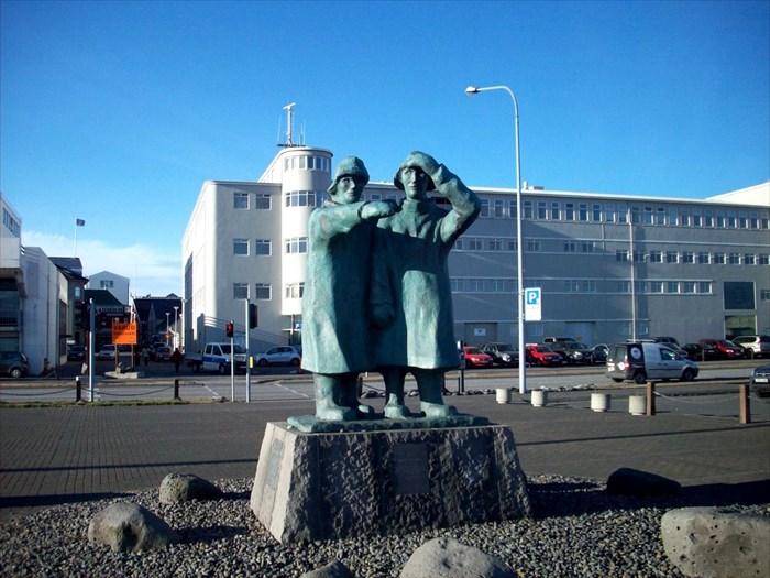
Occupational Statues: Facing the Sea - Reykjavik, Iceland


Interesting Places I've Photographed
Horft Til Hafs (Facing The Sea)
Reykjavik, Iceland
Topic: Occupational Statues


N 64° 08.966 W 021° 56.300


Quick Description: 

A statue honoring fishermen is located in Reykjavik harbor.

Long Description:

The path that parallels the shore in Reykjavik is known as the shore and sculpture walk. As you walk along this path you will encounter several sculptures. At the east side of Reykjavik harbor there is the statue with the title, in Icelandic, "Horft Til Hafs" ("Facing the Sea"). It depicts two fishermen wearing cold water fishing gear (slickers, mittens, boots, and hats) looking northward to the sea. The fisherman on the left has his hand on his hat as if holding it down against the wind. The fisherman on the right is pointing out to sea with his right hand.

The statue was created by Ingi Th. Gíslason and unveiled in 1997. It is meant to remind the citizens of Reykjavik that it was fishermen who were responsible for the prosperity that transformed Reykjavik from a town into a city.

Tuesday, January 8, 2013

Historical Marker: Knox Trail - Otis, MA


Interesting Places I've Photographed
Knox Trail Marker
Otis, MA
Topic: Historical Marker


GPS: N42° 10.695; W073° 02.664

Quick Description: 

Number 5 of 26 markers in Massachusetts to commemorate General Henry Knox's transport of artillery from Fort Ticonderoga to Cambridge.

Long Description:

During he winter of 1775-1776 General George Washington held the high ground around Boston while the British were firmly in control of the city. If Washington had artillery he could dislodge the British and retake Boston. The nearest available artillery was at Fort Ticonderoga, which was under Continental Army control, in up-state New York.

General Henry Knox then was commissioned, in December 1775, by General Washington to secure these artillery pieces and transport them from New York, through Massachusetts, to Dorchester Heights outside Boston. To do this General Knox successfully crossed the Berkshire Mountains and several large rivers, in winter, with fifty-nine pieces of artillery. When the artillery arrived in Boston, in early March 1776, General Howe realized the hopelessness of his position and evacuated the city.

To commemorate this heroic trek a series of 56 historical markers denote the route that General Knox and his men traveled that winter. Twenty-six markers were erected in Massachusetts and thirty in New York for a total of fifty-six. The marker in Blandford is number six in Massachusetts. The marker has a bas relief sculpture of General Knox and his men using oxen to transport artillery and the inscription. 


THROUGH THIS PLACE PASSED
GENERAL HENRY KNOX
IN THE WINTER OF
1775 - 1776
TO DELIVER TO
GENERAL GEORGE WASHINGTON
AT CAMBRIDGE
THE TRAIN OF ARTILLERY
FROM FORT TICONDEROGA USED
TO FORCE THE BRITISH ARMY
TO EVACUATE BOSTON
ERECTED BY THE COMMONWEALTH
OF MASSACHUSETTS 1927

Monday, January 7, 2013

Roadside Attraction/Zippy The Pinhead Location: Frog Rock - Eastford, CT


Frog Rock
"Rawk and Roll"
Eastford, CT


N 41° 52.119 W 072° 03.042

Link to Zippy the Pinhead Comic Strip


Quick Description: 

Frog Rock is located on the north side of U. S. Route 44 in the quiet northeastern Connecticut town of Eastford.


Long Description:

Frog Rock is a painted glacial erratic boulder in a former rest stop along U. S. Route 44 now known as Frog Rock Roadside Park. Westbound traffic can easily spot the pull off which is all that remains of the rest stop. The remainder is overgrown with new growth trees; but the ground retains its broken asphalt pavement. From the pull off you can see the frog through the trees, about 75' into the woods. It's quite a dramatic view.


The frog is painted amphibian green, with a white eye and mouth. The 12' high frog rests a a flat rock ledge in sitting position. This simulacra boulder has been a roadside attraction for quite a while. A nearby rock has painted on it:


Frog Rock
T. J. Thurber
1918 

Sunday, January 6, 2013

Mosaic: Mary & Jesus - Tallinn, Estonia


Mary and Young Jesus
Alexander Nevsky Cathedral
Tallinn, Estonia
Topic: Mosaics


GPS: N59° 26.142; E024° 44.336

Quick Description: 

A golden mosaic of the Mary and Young Jesus occupies the pediment above the main entrance to the Alexander Nevsky Cathedral.

Long Description:

The Alexander Nevsky Cathedral is an Russian Orthodox church on the Toompea Hill section of Tallinn's Old Town, Estonia. It was designed by Mikhail Preobrazhensky in Russian Revival style. Construction began in 1894 and was completed in 1900. At that time present day Estonia was part of the Russian Empire. The cathedral is dedicated to Saint Alexander Nevsky, who in 1242, won the Battle of the Ice on Lake Peipus in Estonia.

In this mosaic, Mary is depicted wearing a scarlet robe with her hands outstretched with her palms up. The image of a young Jesus is contained with a circle inside the image of Mary. Jesus is holding a scroll in his left hand while holding up his right hand with his index and middle fingers crossed. In both cases their heads are encircled by halos. Many of the mosaic tiles in the background are covered with gold.


                                                 Address: 
                                             Alexander Nevsky Cathedral
                                                   Lossi Plats 10
                                                 Tallinn, Estonia

Saturday, January 5, 2013

Musical Instruments: Organ - St. Mary's Church - Rostock, Germany


Interesting Places I've Photographed
Organ of St. Mary's Church
Rostock, Germany
Topic: Musical Instruments


GPS: N54° 05.350; E012° 08.329

Quick Description:

A huge Baroque organ is located in St. Mary's Church in the old Hanseatic City of Rostock


Long Description:

St. Mary's Church organ, the "Marienorgel" was designed by Paul Schmidt, Rostock's organ builder, and installed in 1770. It was rebuilt in 1793 by Ernst Max to correct faults in the wind system. In 1938, the organ was rebuilt again by the Sauer firm of Frankfurt on the Oder.

The organ contains 5,700 pipes and uses 83 stops contained within a magnificant Baroque façade. It is powered by electrical assisted pneumatics operated by four manuals and pedals.

Friday, January 4, 2013

Philatelic Photograph: Motif #1 - Rockport, MA


Interesting Places I've Photographed
Motif #1
Rockport, MA
Topic: Philatelic Photograph


GPS: N42° 39.550; W070° 36.887

Quick Description: 

Motif #1 is located on Bradley Wharf in Rockport, MA.

Long Description:

Motif #1 is the most painted building in America. It is a fishing shack well known to artist and art historians. It was built in the 1840s just when Rockport became a haven for artists. It became the favorite subject for burgeoning and experienced artists. It has since become the iconic symbol of Rockport, Cape Ann, Massachusetts and maritime new England.

Painter Lester Hornby (1882–1956) is believed to be the first to call the shack Motif #1 because of its popularity with artists and the public. Most everyone who visits Rockport takes a photo of this subject.

Converted to a private studio, it was sold to the town in 1945. The shack was destroyed by the blizzard of 1978 and immediately thereafter an exact replica was rebuilt.

The stamp was issued by the United Stated in on April 4, 2002 as Massachusetts' representative in the greetings from America series.

Thursday, January 3, 2013

Barn: School Street Barn - Agawam, MA


Interesting Places I've Photographed
School Street Barn
Agawam, MA 01001
Topic: Barns


GPS: N42° 04.435; W072° 35.560


Quick Description: 

The School Street Barn  is a reminder of New England agricultural heritage. It has just been added to the National Register of Historic Places.

Long Description:

The School Street Barn is located at the site of the former prison farm for the York Street Jail, Springfield, MA., which was once run by the Hampden County House of Corrections. Prisons worked the farm as they were guarded by the local sheriff.

The Prison Farm closed down in the early 1970’s and the land remained unused for many years. In 1998 Hampden County government was abolished and the town of Agawam took possession of the property. It remained unused for many years.

Work began to convert the farm site to a community park - the School Street Park. This abandoned Old Red Barn, on School Street, was left untouched and unused. It still contains the original post and beam animal stalls and a huge hayloft. The barn interior is not open to the public until pending safety issues can be remedied.

Historic barns such as these are disappearing at an alarming rate from the New England landscape because their construction often cannot handle the harsh New England winters.


National Register Of Historic Places Description:

"The School Street Barn in Hampden County, Massachusetts, stands as the last remaining 19th-century barn in Agawam Center. In use as a working barn for approximately 100 years, the School Street Barn is significant for its uncommon use as a major component of a city jail farm, as distinct from a prison farm. In a project that was understood at its time as ground-breaking, the barn was used for farming activities of the Springfield jail that enabled the jail system to: put its minor offenders to work, to raise enough produce to feed inmates, and to save considerable amounts of money. The barn, a central part of the jail’s farm program, was where the farm produce was processed, animals were housed and fed, and equipment was stored. Impetus for buying the farmland came from Hampden County Sherriff David J, Manning, who decided to create a farm jail program for inmates of Springfield’s York Street jail. Manning aimed to bring food into the system and to use his minor offenders (mostly arrested for drunkenness) as farmhands. In 1934, the county bought the first small amount of acreage in Agawam Center, and the School Street Barn farmland was added to the jail farm in two purchases made in 1943 and 1949."

Wednesday, January 2, 2013

Spa: Blue Lagoon, Grindavík, Iceland


Interesting Places I've Photographed
Blue Lagoon
Grindavík, Iceland
Topic: Spa

Relaxing in the Lagoon

Facilities Building
View from Inside the Building
GPS: N63° 52.800 W022° 26.993

Quick Description: 

The Blue Lagoon is a unique attraction of Iceland where you can swim all year around in geothermal seawater.

Long Description:

The Blue Lagoon is located in the town of Grindavík at the southwest corner of Iceland. Set in the middle of a lava field, you enjoy spectacular scenery while you relax in the warm geothermal waters.

Upon entering, you get a wristband which electronically opens a locker. For hygenic reasons, you are required to take a shower before donning your bathing suit. You then enter an airlock connected to the waters of the lagoon to make your way outdoors. The geothermal waters of the lagoon keep the air above the water warm, so you never experience the cold air of Iceland, even in January.

Near the center of the lagoon the water rises up from the earth and forms a cloud of steam. This water is very hot. As you get closer to the cloud the surrounding water gets hotter. Thus, you can always reach that perfect water temperature that suits you best.

On our visit to Iceland, we visited at the Blue Lagoon on our way from Rekyavik to the airport in Kevalik to catch our flight home. There was no better way to end our visit to this beautiful and unique country.

Description from the Official Iceland Tourism Information Site:

"A visit to the Blue Lagoon Iceland geothermal spa is an important part of your stay in Iceland. Guests renew their relationship with nature, soak up the scenic beauty and enjoy breathing the clean, fresh air while relaxing in the warm geothermal seawater.
It is no surprise that the readers of “Conde Nast Traveller” voted Blue Lagoon as the best medical spa worldwide. For five consecutive years Blue Lagoon has been awarded the Blue Flag environmental recognition granted to natural beaches and marinas.

The water’s temperature is 37-39°C / 98-102°F. The lagoon holds six million liters of geothermal seawater, which is renewed every 40 hours. Regular sampling shows that “common” bacteria do not thrive in this ecosystem, thus additional cleansers such as chlorine are not needed."

The Blue Lagoon Website:


Hours of Operation:
June 1 - Aug. 31: 9:00 AM - 9:00 PM
Sept. 1 - May 31: 10:00 AM - 8:00 PM

Admission Prices:
Dates, Adults, Teenagers, Children, Disabled
Jan. 1 - May 31: 33, 15, Free, 15 Euro
June 1 - August 31: 40, 15, Free, 15 Euro
Sept 1 - Dec 31: 33, 15, Free, 15 Euro

Approximate amount of time needed to fully experience the attraction: 
Half of a day (2-5 hours)

Tuesday, January 1, 2013

Holiday Displays: Bright Nights, Poinsettia Candles - Springfield, MA


Interesting Places I've Photographed
Bright Nights
Poinsettia Candles
Springfield, MA
Topic: Holiday Displays


GPS: N42° 05.069; W072° 33.908

Quick Description: 

Bright Nights is an annual display of holiday lighting in Forest Park in Springfield.

Long Description:

For 18 seasons the Bright Nights displays have become a top tourist attraction in New England. From the day before Thanksgiving to New Years Day Forest Park in Springfield is transformed into a fantasy-land of holiday light displays.

Visitors begin their tour by driving into the Sumner Street entrance to the park. The traffic winds it way through 2.5 miles of park road. Displays along the way include, in order:

Poinsettia Fantasy
American Flag
Spirit of the Season
Kwanzaa
Winter Garden
Seuss Land
Letters to Santa
Gift Stop
Snack Bar
Santa's Magical Forest and Cottage
Garden of Peace
Garden of Peace
Jurassic World
Noah's Ark
Victorian Village
Barney Mansion
Leaping Frog
Winter Woods
North Pole Village
Toy Land
Happy Holidays Springfield
Giant Poinsettia Candles

Bright Night Facts:

Number of Displays - 406
Number of Bulbs - 650,000
Days to Set Up - 60
Days to Take Down - 50