Friday, August 31, 2012

Clocks: Prague's Astronomical Clock


Interesting Places I've Photographed
Astronomical Clock
Prague, Czech Republic
Topic: Clocks


GPS: N50° 05.216; E014° 25.244

Quick Description: 

This most intricate and fantastic clock is a Prague icon.

Long Description:

The Astronomical Clock is mounted on the wall of Old Town City Hall in the Old Town Square of Prague. The clock mechanism is composed of three main components: the astronomical dial, representing the position of the Sun and Moon in the sky, "The Walk of the Apostles", an hourly show of figures of the Apostles and other moving sculptures—notably a figure of Death (represented by a skeleton) striking the time, and a calendar dial with medallions representing the months.

The oldest part of the clock and astronomical dial dates back to 1410. It was made by Mikuláš of Kadan and Jan Šindel. Around 1490, the calendar dial was added and clock facade decorated with gothic sculptures. In the 17th century moving statues were added. Figures of the Apostles were added after major repair in 1865-1866.

Thursday, August 30, 2012

National Historical Site - El Morro


Interesting Places I've Photographed
Castillo San Felipe del Morro
San Juan, Puerto Rico
Topic: National Historical Site


GPS: N18° 28.250; W066° 07.451

Quick Description:

El Morro is part of the San Juan National Historical Site. It guards the west end of  Old San Juan, PR

Long Description:

Castillo San Felipe del Morro (El Morro) is called the Gibraltar of the Caribbean. It was build on the western tip of the island that guards the entrance to San Juan harbor. It, together with Castillo San Cristobal, was part of the walled city that constituted the third line of defense against enemy entry. The area within the walled city is now called Old San Juan. The fortifications were built by the Spanish over a span of 250 years beginning in 1539. Spain considered Puerto Rico and the port of San Juan to be the key to maintaining their presence in the New World.

Wednesday, August 29, 2012

Philatelic Photograph: Slater Mill - Pawtucket, RI


Interesting Places I've Photographed
Slater Mill
Pawtucket, RI
Topic: Philatelic Photograph


GPS: N41° 52.647; W071° 22.951

Quick Description: 

Slater Mill is located on Roosevelt Avenue at Pawtucket Falls on the Blackstone River in Pawtucket, Rhode Island.

Long Description:

In 1790, Samuel Slater opened the first successful textile mill in America, thus Slater Mill is considered to be the Birthplace of the American Industrial Revolution. Slater Mill used water power to operate the newly invented machinery that was used to spin cotton. Samuel Slater is recognized as the Father of the American Factory System.

The original portion of the Slater Mill was six bays long and two storeys tall. Additions were made in 1801, 1835 and between 1869 and 1872. The Mill was used for the spinning of cotton until 1895. Thereafter, it was used for various industrial purposes until 1923.

In 1921 the Old Slater Mill Association, a non-profit organization, was founded with the mission of saving the historic Mill. Restoration began in 1923 when modern additions to the structure were removed to return the mill to its appearance in 1835. The Old Slater Mill Museum opened in 1955 and in 1966 it was listed on the National Register of Historic Places.

From 1987 to 1990 the United States issued a series of postage stamps commemorating the bicentennial of the ratification of the Constitution by the 13 original colonies. Rhode Island was the last colony to ratify the Constitution and received the last stamp in the series. The image of the Old Slater Mill as view from across the Blackstone River was chosen for the design.

Tuesday, August 28, 2012

Fountains: Trevi Fountain (Fontana di Trevi) - Rome, Italy


Interesting Places I've Photographed
Trevi Fountain
(Fontana di Trevi)
Rome, Italy
Topic: Fountains


N 41° 54.051 E 012° 28.995

Quick Description: 

Rome's Trevi Fountain is one of the most famous fountains in the world.

Long Description:

The Trevi Fountain is a large Baroque fountain tucked away in a residential section of Rome. It's 26 meters high and 20 meters wide and marks the terminal point the Acqua Vergine aqueduct.  The fountain is a wonderful sight by day but really outstanding at night when it is lit up against a darker background.

Originally a simple basin, in 1730 Pope Clement XII organized a contest to design a new fountain. Eventually, Nicola Salvi was awarded the commission. Work began in 1732. Salvi incorporated many design elements proposed by Gian Lorenzo Bernini 100 years earlier. Work continued for 30 years. Nicola Salvi died in 1751 and the fountain was finished by Giuseppe Pannini in 1762, when Oceanus, god of all water by Pietro Bracci, the final figure, was placed in the center. The fountain was cleaned and refurbished in 1998.

 A traditional legend holds that if visitors throw a coin into the Trevi Fountain, they are destined to return to Rome. You should have your back to the fountain, hold the coin in your right hand and toss it over your left shoulder. Of course, it must land cleanly in the basin of the fountain.

Apparently, based on the popular film Three Coins in the Fountain, several new myths have been circulated. One has it that two coins will lead to a new romance and three coins will ensure either a marriage or, more cynically, a divorce. Some, also, believe you will be blessed with good fortune if you throw three coins with one's right hand over one's left shoulder, in the aforementioned manner, into the Trevi Fountain.

An estimated 3,000 euros are thrown into the fountain each day. Funds are used to help provide food for Rome's needy.

Monday, August 27, 2012

Churches: The Basilique du Sacré Cœur (Basilica of the Sacred Heart)


Interesting Places I've Photographed
Basilique du Sacré Cœur
Paris, France
Topic: Churches


GPS: N48° 53.171; E002° 20.586
Quick Description: 

The Basilique du Sacré Cœur (Basilica of the Sacred Heart) is a Roman Catholic church located at the summit of the Montmartre area of Paris.

Long Description:

A famous Paris landmark, the Basilique du Sacré Cœur is located on the highest point of the city. This large white structure is the most noticeable feature when viewing Paris from the Eiffel Tower. Basilique du Sacré-Cœur was built to atone for the perceived excesses of the Second Empire and the uprising of the Paris Commune of 1871, as it was built in the heart of the rebellious neighborhood. It is also dedicated in honor of the 58,000 who lost their lives during the Franco-Prussian War.

Sunday, August 26, 2012

Barn: Shaker Round Stone Barn


Interesting Places I've Photographed
 
Shaker Round Stone Barn
Hancock, MA
Topic: Barns
 
N 42° 25.835 W 073° 20.202
 
Quick Description: 

The Round Stone Barn is the centerpiece of Hancock Shaker Village in Hancock, MA

Long Description:
The Round Stone Barn, is an architecturally and historically significant, exceedingly efficient, and the only Shaker barn of its kind. It is the iconic symbol of the preserved Hancock Shaker Village.

The Round Stone Barn was built in 1826 by this Shaker community in western Massachusetts. The barn has three levels and is 95' in diameter. The barn was rapidly rebuilt after a fire in 1864. Its distinct circular design was born of labor saving necessity. Shakers were famous for there work saving innovations.

The barn has a lower level where the Shakers fed and milked their cows. They also boarded cows from neighboring farms. Fifty-two cows were led into stalls and their heads were secured in place. Hay wagons were driven up a ramp to the second floor and unloaded. Workers dropped hay down into a wooden central storage area and transferred it to the fed bins. A central ventilation shaft removed potentially inflammable gas from the barn. Cows in the bottom level were positioned for the easy removal of their manure. At the bottom level lay the manure pit, accessible by wagon. Eight to 10 wagon teams can drive around inside the barn at the same time. The interior support system is built with chestnut posts.R

Saturday, August 25, 2012

Arch Bridge: The Bridge of Flowers

Interesting Places I've Photographed
The Bridge of Flowers
Shelburne Falls, MA
  Topic: Arch Bridge  


GPS: N42° 36.230; W072° 44.470
 
Quick Description:
 
The Bridge of Flowers spans the Deerfield River between the towns of Shelburne and Buckland in western Massachusetts.
 
Long Description:

Shelburne Falls is a area in western Massachusetts that is equally divided by the Deerfield River beween the towns of Shelburne and Buckland. In 1908 a 400', five arch, concrete trolley bridge was built to connect Buckland to Shelburne. When the trolley line ceased operation in 1928, residents Antoinette and Walter Burnham conceived the idea of transforming the structure into a flower garden.

The Bridge of Flowers is the only one of its kind in the world. It is administered by the Woman's Club's Bridge of Flowers Committee and maintained with donations, memorial gifts and bequests. From early spring until late fall the bridge is ablaze with thousands of colorful annual and perennial blooms. Over 500 varieties of flowers are represented, insuring continuous blooming throughout the spring, summer and fall. The Bridge of Flowers is open daily during daylight hours.

Friday, August 24, 2012

1000 Places To See Before You Die: Boldt Castle Pump House


Interesting Places I've Photographed
Boldt Castle Pump House
Alexandria Bay, New York
Topic: 1000 Places To See Before You Die


GPS: N44° 20.711; W075° 55.271

Quick Description: 

Boldt Castle and its Pump House is located on Heart Island, one of the 1000 Islands in the St. Lawrence River between the United States and Canada.

Long Description:

Beautiful scenery and millionaire's mansions set on river islands make the 1000 Islands one of the 1,000 places to see before you die. Rocky islands are scattered between the United States and Canada in the upper part of the St. Lawrence River. Many islands have homes built on them. They range from tiny summer cottages to huge millionaire's mansions.

The most opulent of all the mansions and the biggest draw for tourist is Boldt Castle. The castle was built by George Boldt, a millionaire manager of the Waldorf-Astoria Hotel in New York City. The huge castle was intended as a gift for his wife Louise Kehrer Boldt. When she suddenly died, in 1904, construction was halted and George Boldt never visited the property again. After years of neglect and vandalism, the castle has undergone major restoration by the Thousand Islands Bridge Authority.

One of the most unusual features of Boldt Castle is the Pump House. It is built on its own island connected to Heart Island by a stone arch bridge.  It is constructed in the form of a castle and houses the machinery necessary for the maintenance of the island.


Name of Source Book: 1,000 Places To See Before You Die In The United States and Canada
Page Location in Source Book: 204
Cost of Admission: $7.00

Hours, Dates, Season:
Boldt Castle is open daily

May 7th - October 2nd
from 10:00am - 6:30pm.

During July and August
from 10:00am to 7:30pm,

October 3rd to the 10th
from 10:00am to 5:30pm

October 15th and 16th
from 11:00am to 5:30pm.

Thursday, August 23, 2012

Mosque: Sultan Ahmet (Blue) Mosque


Interesting Places I've Photographed
Sultan Ahmet (Blue) Mosque
Istanbul, Turkey
Topic: Mosques


GPS: N41° 00.322; E028° 58.614

Quick Description: 

The Sultan Ahmet mosque  incorporates elements of both Byzantine and Islamic architecture. It is considered to be the last great mosque of the Classical period of Ottoman architecture.

Long Description: 

The domes and minarets of the Sultan Ahmet Mosque (better known as the "Blue Mosque") dominate the skyline of Istanbul. In the 17th century, seventeen year old Sultan Ahmet I wished to build an Islamic place of worship that would be even better than the nearby Hagia Sophia. Construction began two years later, in 1609, and took seven years to complete. The mosque was designed by architect Mehmet Aga. Sultan Ahmet died, at age 27, one year after the mosque was complete.

The interior of the Sultanahmet (Blue) Mosque is vast and richly decorated. It contains more than 20,000 mosaic tiles decorating the interior walls and large central dome and the 8 smaller domes. The main dome is  most striking of all. It is surrounded by a course of windows which light up the blue tiles that give the mosque its common name. Suspended from the dome is a huge chandelier that illuminates the interior of the mosque.

The Sultan Ahmet (Blue) Mosque is open everyday, all year around, but is closed to tourists 5 times a day for short periods for prayer.

Wednesday, August 22, 2012

Maritime & Occupational Monument: Man At The Wheel


Interesting Places I've Photographed
Man At The Wheel 
Gloucester, MA
Topics: Maritime Monument, Occupational Monument


GPS: N42° 36.605; W070° 40.216

Quick Description: 

The iconic Man At The Wheel, aka the Gloucester Fisherman Memorial, is located on Western Avenue on the waterfront in Gloucester.

Long Description:

The sculpture of the Man At The Wheel was commissioned in 1923 for the 300th anniversary of the founding of the City of Gloucester and to honor Gloucester fishermen, especially those lost at sea. Funding for the statue came from the Massachusetts State Legislature and the City of Gloucester. The sculpture was completed in 1925, two years after the city's 300th anniversary.

A 9' by 5' by 47" figure of a Gloucester fisherman is characteristically dressed in rain slicker, boots, and hat. He stands with his right hip touching a ships wheel steering column while his right hand, at 10:30 o'clock, and left hand, at 3:30 o'clock, grasp the wheel. He stares intently at the sea.
The sculpture was created by Leonard Craske and cast in bronze at the Gorham Manufacturing Company foundry. It was commisssioned in 1923 and dedicated August 23, 1925.

On the front of the 5.5' by 4.5' by 4' base is the inscription:


THEY THAT GO
DOWN TO THE SEA
IN SHIPS
1623 - 1923


Tuesday, August 21, 2012

Philatelic Photograph: Wizard Island in Crater Lake


Interesting Places I've Photographed
Wizard Island in Crater Lake
Crater Lake National Park, OR
Topic: Philatelic Photograph; Superlatives (Deepest)


GPS: N42° 55.217; W122° 09.743

Quick Description: 

Wizard Island, an ancient volcanic cinder cone, rises from the westernmost part of Crater Lake.

Long Description:

Crater Lake is the water filled collapsed caldera basin of an extinct volcano, Mount Mazama in the volcanically active Cascade Mountain Range of western Oregon. Since there are no streams entering or leaving the lake, the entire volume of water is derived from rain and melted snow. The average annual precipitation of 66 inches is in equilibrium with the evaporation and seepage rate maintaining the lake level at 6178 feet above sea level. The lake level has varied over a range of merely 16 feet in the past 100 years.

Crater Lake is known to be the deepest lake in the United States and the seventh deepest in the world. According to the United States Geological Service, it has a maximum lake depth of 1,996 feet as measured by sonar.

The extremely deep blue color of the water, for which the lake is famous, is due to the clarity of the water due to lack of suspended sediments. Long wavelengths of light can penetrate quite deeply while only the shorter, blue wavelengths, are scattered back to a viewer on the rim of the caldera.

Wizard Island is an ancient cinder cone, a remnant of the volcano that formed Crater Lake. It is located in the extreme western part of the lake. Wizard Island is 6,933 feet above sea level at its peak or about 755 feet above the lake. The tree covered cone itself has a smaller crater, the "Witch's Cauldron" which is about 500 feet wide and 100 feet deep.

The National Park Service maintains a road - Rim Drive - that follows the top of the caldera which provides excellent views of Wizard Island and Crater Lake.

The stamp was issued by the United States in 1934 as part of the ten stamp National Parks Series. 

Monday, August 20, 2012

Odd Shaped Buildings: Atominum


Interesting Places I've Photographed
Atomium
Brussels, Belgium
Topic: Odd Shaped Buildings


GPS: N50° 53.710; E004° 20.491

Quick Description: 

This 1958 Brussels World's Fair (Expo '58) building is gigantic replica of an iron crystal. 

Long Description:

The Atomium was build as one of the temporary structures for the 1958 World's Fair (Expo '58) held in Brussels, Belgium. It was so popular that it was retained as a permanent attraction after the close of the fair. It has nine large spheres inter-connected to form a body centered cubic crystal of iron. The spheres are connected by tubes which enclose escalators that transport visitors to the exhibit halls, public spaces, a restaurant, and even a dormitory for visiting children. This 335 foot tall structure was designed by André Waterkeyn, and symbolizes the peaceful use of science in the post World War II era.

Sunday, August 19, 2012

Zoomorphic Building/Zippy the Pinhead Location - Lucy The Elephant - Margate City, NJ


Lucy The Elephant
"Tusk, Tusk"
Margate City, NJ


GPS: N39° 19.246; W074° 30.685

Link to Zippy the Pinhead Comic Strip

Short Description: 

Lucy the Elephant has been a famous attraction in Margate, NJ since 1882.


Long Description:

Lucy the Elephant is a 65' high, 60' long, and 18' wide, building made of wood and tin sheeting that weighs about 90 tons. Construction of this huge elephant structure, by James V. Lafferty, began in 1881. It was a promotional endeavor to sell real estate and attract tourism to the area south of Atlantic City, NJ.

Over its long history Lucy has been used as a hotel, restaurant, business office, cottage, and tavern. Today, she is a roadside tourist attraction. Visitors can tour inside Lucy and climb a spiral staircase to reach the observation platform on howdah perched on Lucy's back.


Lucy the Elephant is located at 9200 Atlantic Avenue, Margate City, New Jersey. She is listed on the National Register of Historic Places. 

Saturday, August 18, 2012

Ansel Adams Photo Hunt - Half Dome from Glacier Point.


Interesting Places I've Photographed
Half Dome 
From 
Glacier Point
Yosemite National Park, CA
Topic: Ansel Adams Photo Hunt


Quick Description: 

Both Ansel Adams and I took a picture of Half Dome from Glacier Point.

Long Description:

Some things don't seem to change very quickly. Half Dome from Glacier Point looks exactly the same today as it did when Ansel Adams took this famous black and white photograph in 1947.

Other thing change drastically. Today you could drive to Glacier Point in relative comfort over a paved road and snap an instant full color photo using your SLR digital camera or your even your cell phone camera. In 1947, it would have been an arduous trip to over more primitive roads to reach the same spot, and you would need to develop and print a black and white image from a silver-gelatin negative.

Half Dome is at the eastern end of Yosemite National Park. This huge granite monolith reaches an elevation of 8,842 feet and rises 4,737 feet above the valley floor. It is made up from a type of granite called plutonic rock. The missing half is presumed to have fallen off when the Ice Age glaciers passed through. Some, however, contend that the appearance that half a mountain peak is missing is largely an illusion. Some of the peak was lost to glaciers but the mountain retained much of its original pre-glacier form.

In season, May to November, you can hike the 17 miles to Half Dome and climb the nearly one mile to the summit. Most however will be content to enjoy the iconic view from the coordinates at Glacier Point. While Glacier Point is only about 2 miles from Yosemite Village, its a thirty mile drive along steep curvy roads to reach this very popular viewpoint. Getting there and back easily takes up half a day.

Friday, August 17, 2012

Philatelic Photograph: English Harbour from Shirley Heights


Interesting Places I've Photographed
English Harbour
 from 
Shirley Heights, Antigua and Barbuda


GPS: N17° 00.137; W061° 45.296

Quick Description: 

The view of English Harbour from Shirley Heights

Long Description:
At the southeast part of the island of Antigua the British built a naval base at English Harbor to support the ships that protected their interests in the Caribbean. This naval base is now called Nelson's Dockyards in honor of Admiral Horatio Nelson who was the commander of the naval base during its heyday in the 18th century. To protect the dockyard several military fortifications were build. 

At overlooking English Harbour is a strategic site called Shirley Heights, named after General Thomas Shirley, Governor of the Leeward Islands.  This area was once a large military complex, spread out along a ridge, for the defense of the island. There you will find old barracks buildings, a cemetery, a blockhouse, and the lookout. From this lookout you can enjoy the exact same view of the harbor as shown on the 1938 stamp from Antigua. 

The slender peninsula jutting out towards you is Fort Berkeley, whose gun emplacements protected the entrance to the naval base. Nelson's Dockyards are to right and the town of English Harbour is located just below and nestled against the harbor. The Nelson's Dockyards and Fort Berkeley have been restored to their 18th century appearance and the town of English Harbour still retains its earlier charm.


Thursday, August 16, 2012

Maritime Monuments and Memorials - Titanic Centennial Memorial


Interesting Places I've Photographed
Titanic Centennial Memorial
Springfield, MA
Topics: Maritime Monuments and Memorials, Disaster Memorials


GPS: N42° 07.260; W072° 33.858

Quick Description: 

A memorial to the victims of the Titanic disaster is located in the Oak Grove Cemetery in Springfield, MA

Long Description:

On the 100th anniversary of the sinking of the Titanic and in memory of the 1,517 people who died in this maritime disaster, the Titanic Historical Society has erected a black granite memorial in Springfield's Oak Grove Cemetery. The monument was conceived by Paul A. Phaneuf, a member of the Titanic Historical Society, which is has its headquarters in the nearby Indian Orchard section of Springfield.
The 6' high by 7' long and 2' wide memorial has the image of the Titanic laser etched on one side. Underneath is inscription:


R.M.S. TITANIC APRIL 15, 1912

The back of the memorial specifically names the two Springfield residents who died with the sinking of the ship: Milton C. Long and Jane Carr. Milton C. Long was twenty-nine years old. He was the son and only child of Charles C. Long who was a judge and former Mayor of Springfield. Jane Carr was a forty-seven year old immigrant who worked in Springfield and returned home to Ireland in 1909. She was returning to settle her affairs in the United States before, once again, returning to Ireland.
The back of the memorial contains the emblem of the Titanic Historical Society and is inscribed:


In memoriam to all those who sailed on the
Royal Mail Steamer TITANIC
and Springfield passengers, Milton C. Long and Jane Carr
on the 100th Anniversary April 15, 1912

May the memory of Titanic be preserved forever
"Nearer, My God, to Thee"

Erected by the Titanic Historical Society, Inc., Indian Orchard, Massachusetts

The memorial was erected on April 4, 2012 with formal ceremonial dedication on April 21, 2012. Parking is available on the cemetery roads adjacent to the monument.


Wednesday, August 15, 2012

1000 Places To See Before You Die: Geirangerfjord - Geiranger, Norway


Interesting Places I've Photographed
Geirangerfjord
Geiranger, Norway

Topic: 1000 Places To See Before You Die


GPS: N62° 06.208; E007° 12.350

Quick Description: 

If you enjoy mountains, coastlines, and waterfalls then Geirangerfjord, Norway,  arguably, offers the most spectacular scenery on the planet.

Long Description:

Geiranger is a sleepy little town at the end of Geirangerfjord. There is only one reason why it's a Mecca for tourist - the fantastic scenery. The deep blue waters of the fjord are surrounded on three sides by towering cliffs with waterfalls everywhere you look. Its a breath-taking sight.

There are two famous lookouts offering broad vistas. Flydalsjuvet Lookout is easily accessible from route 63, about 4 km from the center of Geiranger south by southeast of Geiranger. From here you look down on the town of Geiranger across length of the fjord towards the North Atlantic. The lookout points are on two plateaus, one higher and one lower with a footpath linking the two. The lookout points have been modernised as part of the "Nasjonale turistveier" project. The new facilities were officially opened at a ceremony on 21 June 2006.

Dalsnibba is the other lookout. It is situated north of town on the famous Eagle's Road (Ornevegen) which itself is an engineering marvel. Eleven hairpin turns take you up a steep cliff to the plateau and the viewing area. From the Dalsnibba plateau there is a awe inspiring view across a most beautiful landscape with Geiranger in the middle surrounding by mountains with Geirangerfjord right in the middle.

When you cruise along this 9.3 mile long fjord is seems you can almost reach out and touch the sheer cliffs on both sides. You pass many waterfalls along the way. So many that it would be difficult to get pictures of them all. The two most famous are The Seven Sisters on the east side of the fjord just north of Geiranger and Bridal Veil Falls a little farther north on the western cliff.

The fjord is one of Norway's most visited tourist sites and has been listed as a UNESCO World Heritage Site since 2005.

Name of Source Book: 1000 Places To See Before You Die
Page Location in Source Book: 331
Type of Waymark: Scenic
Location of Coordinates: The dock at Geiranger

Tuesday, August 14, 2012

Lion Statues: The Lion of Lucerne Monument


Interesting Places I've Photographed
The Lion of Lucerne Monument
Lucerne, Switzerland
Topic: Lion Statues


GPS: N47° 03.493; E008° 18.636

Quick Description: 

The Lion of Lucerne is a large relief sculpture of a sleeping lion carved into the side of a small cliff in Lucerne,    Zentralschweiz,  Switzerland

Long Description:

The Lion Monument (Löwendenkmal) is often called the Lion of Lucerne. It is a relief sculpture that was designed by the Danish sculpture Bertel Thorvaldsen and carved by Lukas Ahorn between 1820 and 1821.

On August 10, 1792, members of the Swiss Guard were killed when revolutionaries stormed the Tuileries Palace in Paris during the French Revolution. At that time, the Swiss Guard was hired to protect the French royalty. About 760 members of the Swiss Guard were killed during the fighting or massacred after surrender. The majority of the Swiss Guard who survived were away at Normandy at the time. A mournful sculpture of a mortally wounded lion commemorates their dedication and loss.

The sculpture is carved in what was once a sandstone quarry. Above the lion is the dedicatation: "Helvetiorum Fidei ac Virtuti" - ("To the loyalty and bravery of the Swiss"). The dying lion is impaled by a spear. He is leaning on a shield bearing the fleur-de-lis of the French monarchy and in front of him is a second shield with the Swiss the coat of arms. The inscription below the sculpture lists the names of the officers, and approximate numbers of the soldiers who died (DCCLX = 760), and survived (CCCL = 350).

Monday, August 13, 2012

Photo, Then and Now - Miles Morgan Statue in Court Square, Springfield, MA


Interesting Places I've Photographed
Miles Morgan Statue in Court Square
Springfield, MA
Topic: Photos Then and Now; Statue of an Historic Figure


GPS: N42° 06.078; W072° 35.334


Quick Description: 

Miles Morgan Statue in Court Square - 1908 and 2011

Long Description:

The Miles Morgan statue has not changed but what a difference in the buildings surrounding Court Square in Springfield, MA. Looking north across Court Square there are three new buildings in the 2011 photo are (from left to right):

City Hall (neo-classical building)- built in 1913
Monarch Place (26 floors postmodern glass skyscraper) - built in 1987
One Financial Plaza - (17 floors Sovereign Bank building) - built in 1982

Year old photo was taken: 1908
Year new photo was taken: 2011
Time difference: 103 years.

Sunday, August 12, 2012

Famous Fictional Characters, Roadside Attraction - Alice in Wonderland Sculpture


Interesting Places I've Photographed
Alice in Wonderland (Margaret Delacorte Memorial)
New York, New York
Topics: Famous Fictional Characters, Roadside Attraction


GPS: N40° 46.502; W073° 57.992

Quick Description:

Large, bronze sculpture of Alice and her friends from the Lewis Carroll classic - Alice's Adventures in Wonderland is located in Central Park in New York City.

Long Description:

The statue of Alice and some of the characters from Lewis Carroll's Alice's Adventures in Wonderland is located in Central Park just west of 5th Avenue and 76th Street. This bronze statue was commissioned by George Delacorte as a gift to the children of New York and placed in Central Park in 1959. The statue was also meant as a tribute to his late wife, Margarita, who read Alice to their children. Plaques surround the statue with lines from Carroll's nonsense poem, The Jabberwocky.

The statue was created by the Spanish-born American sculptor José de Creeft. The design was taken from illustration by John Tenniel used in the first published edition of the book. It shows Alice (with the face of Creeft's daughter), sitting on a mushroom, surrounded by the the March Hare, the Mad Hatter (a caricature of George Delacorte), the Cheshire Cat, Alice's cat Dinah, and the Dormouse.

---------------------------------------------------------------------

Data from the Smithsonian Art Inventory:

Artist: de Creeft, Jose, 1884-1982, sculptor.
Sasaki, Hideo, landscape architect.
Texidor, Fernando, designer.
Sandor, Karsay, assistant.
Modern Art Foundry, founder.

Title: Alice in Wonderland, (sculpture).
Other Titles: Margaret Delacorte Memorial, (sculpture).

Dates: 1959. Dedicated May 7, 1959.

Medium: Sculpture: bronze; Base: Chelmsford granite and stones.

Dimensions: Sculpture: approx. H. 11 ft. Diam. 16 ft.; Base: H. 1 ft. Diam. 39 ft.

Inscription: (Front right:) Jose de Creeft/sculptor (Front left:) F. Texidor/project designer/KarsaySandor/1959 (Back left:) Modern Art Foundry/N.Y. signed Founder's mark appears.

Description: A depiction of the various characters from "Alice in Wonderland" including Alice and her cat Dinah, the March Hare, the Mad Hatter, the Dormouse, and the Cheshire Cat. Alice is seated in the middle on a large mushroom.

Owner: Administered by City of New York, Department of Parks and Recreation, The Arsenal - Central Park, New York, New York 10021 Located by Central Park, Conservatory Pond, New York, New York

Remarks: This piece was commissioned by George Delacorte and was a gift of the George and Margarita Delacorte Foundation. The project designer for the piece was Fernando Texidor. The piece was designed so that children could climb on it.

Saturday, August 11, 2012

Abstract Sculpture, Philatelic Photograph - Sólfar (Sun Voyager) Sculpture and Esja Mountain


Interesting Places I've Visited
Sólfar (Sun Voyager) Sculpture 
and 
Esja Mountain
from 
Reykjavík Harbor
Reykjavík, Iceland
Topics: Abstract Sculpture, Philatelic Photograph


GPS: N64° 08.859; W021° 55.349

Quick Description: 

Two great photo-ops from the same location. The Sólfar (Sun Voyager) Sculpture and  Esja Mountain. 

Long Description:

One of the most interesting sights in Reykjavík is the sculpture of a Viking ship, Sólfar (Sun Voyager) by Jón Gunnar Árn. From nearby, if you look to the northeast over the bay, on a clear day, you will be treated to this view of Esja Mountain which is about 6 miles north of Reykjavík Harbor. 

Esja is a volcanic mountain range with an elevation of about 3000 feet. It is a popular recreation area for hikers and climbers.

The single stamp souvenir sheet was issued by Iceland in 2001 to commemorate Stamp Day.

Friday, August 10, 2012

Philatelic Photograph: Monument to the Discoveries

Monument to the Discoveries
(Monumento dos Descobrimentos)
Lisbon (Belém)
 Portugal


GPS: N38° 41.628; W009° 12.342

Quick Description: 

View from the west, the profile of the Monument to the Discoveries. This monument is located on the banks of the Tagus River in Santa Maria de Belém section of Lisbon.

Long Description:

Monument to the Discoveries is aptly placed since early sailors passed through this spot when they embarked and returned from their voyages of discovery. The Portuguese Age of Discovery began 1381 when the Portuguese explored the Canary Islands and continued for two hundred years and reached as far away as Japan. During that time the Portuguese established colonies in Africa, Asia and South America.

The major impetus for this activity was Prince Henry the Navigator. He formalized the study of navigation, naval architecture, and astronomy and developed the powerful ship called the caravel, which contributed to Portuguese supremacy on the high seas.

The monument was designed by architect José Ângelo Cottinelli Telmo and sculptor Leopoldo de Almeida as a temporary display during the Portuguese World Fair in June 1940. It was demolished after the fair in 1943.

In 1958, construction began on a permanent limestone monument which was unveiled at its present location in January 1960, to commemorate the 500th anniversary of the death of Henry the Navigator.

Figures visible on the photograph of the profile are (from left to right):

Henry the Navigator
Afonso V of Portugal
Vasco da Gama (discoverer of the sea route to India)
Afonso Gonçalves Baldaia (navigator)
Pedro Álvares Cabral (discoverer of Brazil)
Ferdinand Magellan (first to circumnavigate the globe)
Nicolau Coelho (navigator)
Gaspar Corte-Real (navigator)
Martim Afonso de Sousa (navigator)
João de Barros (writer)
Estêvão da Gama (sea captain)
Bartolomeu Dias (first to cross over the Cape of Good Hope)
Diogo Cão (first to arrive to the Congo river)
António Abreu (navigator)
Afonso de Albuquerque (second viceroy of Portuguese India)
Saint Francis Xavier (missionary)
Cristóvão da Gama (captain)


Thursday, August 9, 2012

National Register of Historic Places: Bulfinch Building - Massachusetts General Hospital


Interesting Places I've Photographed
Massachusetts General Hospital (Bulfinch Building)
Boston, MA


GPS: N42° 21.798 W071° 04.076

Quick Description: 

The Bulfinch Building, the original building of the Massachusetts General Hospital, is listed in the National Register of Historic Places.

Long Description:
Massachusetts General Hospital, one of the world's foremost medical institutions. It was founded in 1799 when a $5,000 bequest was made to establish a hospital in Boston. The original building was designed by the noted architect Charles Bulfinch. The building was constructed of Chelmsford granite in the Greek Revival style. It opened in 1821. The building is still used today, and houses specialized offices for the hospital.

The dome in the center of the building contains an operating room and gallery. More than 8,000 operations were performed in this theater from 1821 to 1868. It was here that ether was first successfully used as an anesthetic during surgery. This operating room became known as the Ether Dome. Today the Ether Dome is a medical museum which houses a variety of medical artifacts and curiosities. The Ether Dome has a separately listing in the National Register of Historic Places.

The building is symmetrical with the Ether Dome in the center. Below the dome is the original entrance. A series of stair lead up to a portico which is surrounded by eight Ionic columns. To the left and right are the office wings of the building, each having three levels of windows. The building is located at the end of a landscaped courtyard surrounded by the newer towering buildings of the Massachusetts General Hospital.

Street address:
55 Fruit Street
Boston, MA United States
02114


County: Suffolk
Year listed: 1970
Historic significance: Event, Architecture/Engineering 
Period of significance: 1825-1849, 1800-1824
Historic function: Health Care
Current function: Health Care

Wednesday, August 8, 2012

National Register of Historic Places: Ether Dome


Interesting Places I've Photographed
Ether Dome
Boston, MA


GPS: N42° 21.798; W071° 04.076

Quick Description: 

The Ether Dome is located in the Bulfinch Building of the Massachusetts General Hospital in Boston.

Long Description:

The Ether Dome Amphitheater was the Massachusetts General Hospital's operating room 1821 until 1867. On October 16, 1846, the Boston dentist William Thomas Green Morton was the first person to use inhaled ether to anesthetize Edward Gilbert Abbott. This enabled the Dean of the Harvard Medical School, John Collins Warren, to painlessly removed a tumor from Abbott's neck. Afterwards the patient felt only as if his neck had been scratched; in contrast to a less than successful attempt by Horace Wells, the previous year, to use nitrous oxide. Before 1846 this site was simply called the surgical amphitheater. After 1846 it became known as the Ether Dome.

Originally, lighting was solely by natural sunlight, hence the purpose of the copper sheathed dome on the building. The room itself had seven tiers of wooden amphitheater seating. In 1849, gas lanterns were introduced to the operating site and late in the 19th century electrical lights were installed. In 1956 new light fixtures and motorized louvers were added to the skylight and all the windows were replaced. The dome and cupola are now lit by a ring of lights at the base of the cupola. The Ether Dome was used as a storage area until 1873, a dormitory until 1889, a dining room for nurses until 1892, and is now used as a conference room and teaching amphitheater. A statue of Apollo, casted in the Louvre in Paris, France, decorates the entrance to the Ether Dome. It was given to the Massachusetts General Hospital in March 1845 by Edward Everett.

The Bulfinch Building that houses the Ether Dome was designed by noted architect Charles Bulfinch. Construction began on July 4, 1818. During construction Bulfinch was called upon to the design the Nation’s Capitol. Construction of the building was completed under the direction of Alexander Parris. The facility opened in 1821 and between 1821 and 1868 more than 8,000 operations were performed in the operating room.

Hours and Admission
Monday – Friday
9:00 am to 5:00 pm
Closed during faculty meetings
Admission: Free

Street address:
55 Fruit Street
Boston, MA United States
02114

County: Suffolk
Year listed: 1966
Historic significance: Event
Period of significance: 1825-1849 
Historic function: Health Care
Current function: Health Care
Privately owned?: yes

Tuesday, August 7, 2012

Roadside Attraction: The Ether Monument


Interesting Places I've Visited
The Ether Monument
Boston, MA
Topics: Roadside Attraction, Smithsonian Art Inventory Sculpture


GPS: N42° 21.290; W071° 04.284

Quick Description: 

The Ether Monument, also known as the Good Samaritan, is the oldest monument in the Boston Public Garden, Boston, MA. It commemorates the first use of ether as an anesthetic during surgery.

Long Description:

The Ether Monument, also known as the Good Samaritan, was commissioned by Thomas Lee and commemorates the discovery ether and its use as an anesthetic in surgery performed at Massachusetts General Hospital October 16, 1846. John Quincy Adams Ward was chosen to be the sculptor and Henry Van Brunt the architect. The monument was dedicated in the Boston Public Garden on September 26, 1868.

The first public surgery using anesthetic took place at the Massachusetts General Hospital on October 16, 1846. The Boston dentist William Thomas Green Morton was the first person to use inhaled ether to anesthetize Edward Gilbert Abbott. This enabled the Dean of the Harvard Medical School, John Collins Warren, to painlessly removed a tumor from Abbott's neck. Afterwards the patient felt only as if his neck had been scratched; in contrast to a less than successful attempt by Horace Wells, the previous year, to use nitrous oxide.

A 40' tall granite fountain sits in a square granite basin having a brick floor. A 35' decorative granite and marble column rises from the basin. On the top of the column is a 6' high sculpture of two figures. A Good Samaritan is wearing a beard, robe and turban. He has his left arm around the shoulders of an disrobed, curly haired, unconscious man. The Samaritan is holding a compress to the torso of the unconscious man. Four bas relief sculptures adorn each side of the column.
The south relief depicts an operation using anesthesia. The doctors wear a mix of nineteenth century and classical dress. Below is the inscription:


TO COMMEMORATE
THE DISCOVERY
THAT THE INHALING OF ETHER
CAUSES INSENSIBILITY TO PAIN
AT THE
MASS. GENERAL HOSPITAL
IN BOSTON
OCTOBER A. D. MDCCCXLVI

On the north side a Union Civil War field surgeon stands ready to amputate a wounded soldier's leg. The soldier is asleep under the influence of ether. Below is the inscription:


IN GRATITUDE
FOR THE RELIEF
OF HUMAN SUFFERING
BY THE INHALING OF ETHER
A CITIZEN OF BOSTON
HAS ERECTED
THIS MONUMENT
A. D. MDCCCLXVII

THE GIFT OF THOMAS LEE

On the east side an angel hovers above a suffering man. Below is an inscription from the Book of Revelation:


NEITHER SHALL THERE BE ANY MORE PAIN
REV

On the west side a woman, representing Science, sits on a throne of laboratory glassware and laboratory apparatus while a Madonna and Child look on with approval. Above is an inscription from the Book of Isaiah:


THIS ALSO COMETH FORTH
FROM THE LORD OF HOSTS
WHICH IS WONDERFUL
IN COUNSEL,
AND EXCELLENT
IN WORKING

ISAIAH


Monday, August 6, 2012

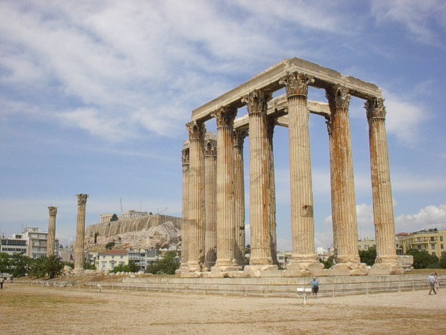
Preserved Architectural Remnants and Ruins: Temple of Olympian Zeus

Interesting Places I've Photographed
Temple of Olympian Zeus
Athens, Greece
Topic: Preserved Architectural Remnants and Ruins

 
GPS: N37° 58.162; E023° 43.982
 
Quick Description:
The southeast corner and a pair of freestanding columns are all that remain of the massive Temple of Olympian Zeus in Athens.
 
Long Description:
The Temple of Olympian Zeus, also known as the Columns of the Olympian Zeus, is a large temple ruin located near the center of Athens. Construction began in the 6th century BCE during Athenian rule and it was completed 638 years later in the 2nd century AD under the rule of the Roman Emperor Hadrian. Upon completion it was the largest temple in Greece.

The temple fell into disuse following a barbarian invasion in the 3rd century AD and fell into ruins. The stone was quarried for building materials. Today a section of connected columns remain on the southeast corner of the site. To the west are two freestanding columns flanking a fallen column.

Sunday, August 5, 2012

Smokey Bear Sighting: Vintage Smokey

Vintage Smokey Bear Sign
Hopkington, MA
Topic: Smokey Bear Sightings
Quick Description:
This vintage Smokey sign is on display attached to a utility shed at the Hopkington State Park Headqarters, Hopkington, MA.
Long Description:
This old Smokey sign carries the familiar slogan "Remember! Only You Can Prevent Forest Fires". When we spotted this sign on the grounds of the Hopkington State Park Headquarters both my spouse and I recalled the words from the Smokey song from the '50 public service announcements on TV. It went something like this: 

Smokey - the Bear, Smokey - the Bear;
A prowlin' and a growlin' and a sniffin' the air;
He can find a fire before it starts to flame;
That is why they call him Smokey;
That is how he got his name.

Saturday, August 4, 2012

Fountain: The Three Queens of the Virgin Islands


Interesting Places I've Photographed
The Three Queens of the Virgin Islands Fountain
Charlotte Amalie, St. Thomas, United States Virgin Islands


GPS: N18° 20.599; W064° 55.780

Quick Description: 
Three Queens of the Virgin Islands fountain is located below Blackbeard's Castle in Charlotte Amalie on St. Thomas Island.

Long Description:
Three former slaves that led a labor revolt in the Danish Virgin Islands, now the U.S. Virgin Islands, are honored with this fountain located on a hill above the city of Charlotte Amalie. Bronze sculptures of the women known as Queen Mary, Queen Agnes and Queen Matilda are subject of this fountain.
The women are shown standing back to back forming a triangle. All three women are wearing long dresses, aprons and long sleeved blouses. The woman on the left carries a lantern in her right hand. The central figure holds a harvesting tool in her right hand and a torch in her left. The woman on the right holds a torch in her right hand. The stand on in a circular basin surrounded by jets of water. the fountain is surrounded by a lawn and vegetation. At the south end of the vegetation there is a bronze plaque with the inscription:

THE THREE QUEENS OF THE VIRGIN ISLANDS


In 1878 three former slave ladies on St. Croix led an
insurrection against the Danish Government for improved
working and living conditions. During this action a major
portion of Frederiksted was destroyed by fire. This revolt
is known today as "FIREBURN" and the ladies are
renowned as "Queen Mary, Queen Agnes and Queen 
Matilda" - The Three Queens of the Virgin Islands.

Friday, August 3, 2012

Roadside Attraction; Monument to Jefferson's Mammoth Cheese


Interesting Places I've Photographed 
Monument to Jefferson's Mammoth Cheese
with a Plaque Honoring John Leland
Cheshire, MA

Topics: Roadside Attraction; Religious Freedom; Realistic Object Sculpture


GPS: N 42° 33.736; W073° 09.469

Quick Description: 
A concrete sculpture of a cheese press and a plaque honors John Leland and a 1255 pound Cheshire cheese is located in Cheshire MA. The cheese press commemorates a 1255 pound cheese that was produced in Cheshire and presented to the newly elected President Thomas Jefferson.


Long Description:
John Leland was born on May 14, 1754 in Grafton, MA. As Baptist preacher in Virginia and Massachusetts, he was a staunch abolitionist and advocate for religious freedom in the United States. He was an early exponent of the "liberty of conscience" religious philosophy with regard to public policy and helped get the First Amendment to the Constitution adopted despite widespread opposition from his fellow religious leaders. His philosophy can be clearly seen in the following quote.


"The notion of a Christian commonwealth should be exploded forever...Government should protect every man in thinking and speaking freely, and see that one does not abuse another. The liberty I contend for is more than toleration. The very idea of toleration is despicable; it supposes that some have a pre-eminence above the rest to grant indulgence, whereas all should be equally free, Jews, Turks, Pagans and Christians." -
From - A Chronicle of His Time in Virginia.

A plaque listing his John Leland's accomplishments is located on a sculpture of a cheese press on the corner of Church and School Streets in the center of Chester. The plaque is inscribed:


1754 {IMAGE OF JOHN LELAND} 1841

ELDER JOHN LELAND

ELOQUENT PREACHER BELOVED PASTOR
INFLUENTIAL PATRIOT
FATHER OF RELIGIOUS LIBERTY

WITH JAMES MADISON CARRIED VIRGINIA
IN THE ADOPTION OF THE CONSTITUTION
OF THE UNITED STATES AND THE FIRST
AMENDMENT, DESPITE OPPOSITION OF EVERY
OTHER PULPIT IN MASSACHUSETTS
CARRIED EVERY VOTE IN CHESHIRE FOR THE
ELECTION OF
PRESIDENT THOMAS JEFFERSON
AND PRESENTED TO HIM ON JAN. 1, 1802 IN THE EAST ROOM
OF THE WHITE HOUSE IN THE PRESENCE OF FOREIGN
DIPLOMATS, SUPREME COURT JUDGES
AND THE CONGRESS
THE BIG CHESHIRE CHEESE
WEIGHING 1255 LBS.
DEDICATED BY
THE SONS OF THE AMERICAN REVOLUTION
1940

Thursday, August 2, 2012

National Register of Historic Places: Portland Head Light

Interesting Places I've Photographed
Portland Head Light
Cape Elizabeth, Maine
Topics: National Register of Historic Places; Coastal Lighthouses


GPS: N43° 37.388; W070° 12.475


Quick Description: 
Portland Head Light is the first lighthouse built by the United States government, in 1787.

Long Description:
Portland Head Light is the oldest and arguably the most famous and photographed lighthouse in America built by the government. It was constructed at the direction of President George Washington and Secretary of the Treasury Alexander Hamilton from a design by Jonathan Bryant and John Nichols in 1787.

This historic lighthouse is located in Cape Elizabeth at the entrance to Casco Bay and is now a part of Fort Williams Park. The light has been upgraded over the years. In 1855, a fourth-order Fresnel lens was installed only to be replaced by a second-order Fresnel lens. That in turn was replaced by an aero beacon in 1958 until a DCB-224 aero beacon was installed in 1991.

Portland Head Light is 80 feet above ground and 101 feet above the Atlantic Ocean. The DCB 224 beacon, rated at 200,000 candlepower, is visible from 24 miles out to sea. The grounds, and keeper's house are owned by the town of Cape Elizabeth, while the beacon, and fog signal are owned and maintained by the U.S. Coast Guard. It was added to the National Register of Historic Places on April 24, 1973 (reference #73000121)

Museum and Gift Shop are open daily 10 a.m. to 4 p.m


Street address:
1000 Shore Rd.
Cape Elizabeth, ME United States
04107

County: Cumberland
Year listed: 1973
Historic significance: Event, Architecture/Engineering
Period of significance: 1875-1899, 1750-1799
Historic function: Defense, Domestic, Government, Transportation
Current function: Defense, Domestic, Government, Transportation
Privately owned?: no
Hours of operation: From: 10:00 AM To: 4:00 PM


Wednesday, August 1, 2012

Philatelic Photograph; Beatlemania - The Knotted Gun


Interesting Places I have Photographed. 
Topics:  Beatlemania,  Philatelic Photograph
Knotted Gun (Non-Violence) Sculpture
United Nations, New York


GPS: N40° 45.046; W073° 58.063

Quick Description: The Knotted Gun (aka Non-Violence) sculpture is a memorial to John Lennon and the model for Ringo Starr's design for the Non-Violence Foundation memorial to John Lennon.

Long Description:
After the death of John Lennon at the hands of Mark David Chapman on December 8, 1980, Yoko Ono asked his grieving friend, the sculptor Carl Fredrik Reuterswärd, to create a tribute to John and his vision and advocacy for a more peaceful and non-violent world as expressed in the lyrics of many of his songs, particularly his 1971 song - Imagine.

"You may say that I'm a dreamer
But I am not the only one
I hope someday you'll join us
And the world will live as one"

The result was the the famous bronze sculpture “The Knotted Gun” which is now located in the plaza at the entrance to the United Nations Building in New York City.

The Knotted Gun was was originally located at the Strawberry Fields Memorial in Central Park. It is just across the street from the Dakota, where John Lennon and Yoko Ono lived. In 1988, the Knotted Gun was placed outside the United Nations headquarters in New York. At the dedication, UN Secretary General Kofi Annan, described the symbolism:

"The sculpture, Non-Violence, has not only endowed the United Nations with a cherished work of art; it has enriched the consciousness of humanity with a powerful symbol that encapsulates, in a few simple curves, the greatest prayer of man; that which asks not for victory, but for peace"

The Knotted Gun has become a worldwide symbol of the non-violence movement. Many replicas of this sculpture can be found around the world, including, the Olympic Museum in Lausanne, at the Waterfront in Cape Town and in the Peace Park in Beijing, China.

More recently the Non-Violence Foundation commissioned former Beatle Ringo Starr to create his own rainbow-colored interpretation of the Knotted Gun to commemorate the 31st anniversary of John Lennon’s murder. The sculpture carries the inscription IMAGINE. The sculpture was unveiled in London in December 2011.

Location: 
United Nations
405 East 42nd Street
New York, NY 10017

posted: August 1, 2012