Friday, December 26, 2014

Roadside Attraction: Boxing Champion Tony DeMarco - Boston, MA

Boxing Champion
 Tony DeMarco
Boston, MA


N 42° 21.751 W 071° 03.333

Short Description: 

A statue of welterweight boxing champion Tony DeMarco is located at the corner of Hanover and Cross Street in the north End of Boston.

Long Description:

A 6' high bronze statue of legendary boxer Tony DeMarco was unveiled on October 20, 2012 at the entrance to the North End neighborhood in Boston where DeMarco grew up. DeMarco is standing on a 2.5' high by 6' square and tapered polished black granite base. DeMarco depicted in boxing trunks and footwear. He is in a boxing stance with his right foot forward while leading with his left hand. The statue was created by Harry Weber.


There are two bronze plaques attached to the base of the statue. The west side plaque is inscribed:


"THE FLAME AND THE FURY OF FLEET STREET"
TONY DEMARCO
* UNDISPUTED HEAVYWEIGHT CHAMPION OF THE WORLD *
* KO'D JOHNNY SAXON APRIL 1, 1955 BOSTON GARDEN *
* BORN ON FLEET STREET IN BOSTON'S NORTH END *
* FOUGHT 8 WORLD CHAMPIONS *
* DEMARCO VS . BASILIO CHAMPIONSHIP BOUTS
VOTED TWO OF THE TEN GREATEST FIGHTS OF ALL TIME *
~
MASSACHUSETTS CHAPTER OF
THE NATIONAL ITALIAN AMERICAN SPORTS HALL OF FAME
COMMITTEE MEMBERS
* BILL SPADAFORA, PRESIDENT * DONATO FRATTAROLI * CHRIS ZIZZA
* VICTOR CORDA * RICH CAPPIELLO 
~
STATUE GIFT OF BY THE PRIVITERA FAMILY CHARITABLE FOUNDATION FAMILY CHARITABLE FOUNDATION

The south side plaque is inscribed:


GIFT OF
PRIVITERA FAMILY
CHARITABLE FOUNDATION
PRESIDENT PHILIP J. PRIVITERA
CHAIRMAN FRANCIS D. PRIVITERA
TRUSTEE JEANINE PRIVITERA TRUSTEE FRANCIS D. PRIVITERA JR.
***
THIS STATUE OF
TONY DEMARCO
WELTERWEIGHT CHAMPION OF THE WORLD 1955
IS A GIFT TO 
THE NATIONAL ITALIAN-AMERICAN
SPORTS HALL OF FAME

IN LOVING MEMORY OF
JENNIE "JEAN" PRIVITERA
APRIL 5, 1936 - AUGUST 11, 2009
DEDICATED
OCTOBER 20, 2012

A third plaque contains a list of sponsors.

Tony DeMarco (née Leonardo Liotta) was born on January 14, 1932 to Sicilian immigrants, Vincent and Giacomina Liotta, in the North End neighborhood of Boston.

Wikipedia provides the following details of his life and career. Wikipedia Link

Underage Leonardo Liotta used Tony DeMarco's birth certificate so he could complete in is first fight at age 16 on October 21, 1948. He knocked out is opponent, Mestor Jones, in one round. He went on to compile a record of:

71 fights
58 wins
38 wins by KO
12 losses
1 draw

Roadside Attraction: Boxing Champion Rocky Marciano Memorial - Springfield, MA

Boxing Champion
Rocky Marciano Memorial
Springfield, MA


N 42° 05.898 W 072° 34.991

Short Description: 

A memorial dedicated to undefeated heavyweight boxing legend, Rocky Marciano, is located in the South End neighborhood of Springfield.

Long Description:


Italian immigrants to Springfield settled in Springfield's South End neighborhood. Although later generations have move on, the area is still home to a variety of Italian specialty shops. At the southeast corner of Main and William Street, at the edge of a parking lot for a popular store at 889 Main Street, is a monument to Rocky Marciano. The inscription reads:


{Image of Rocky Marciano boxing}
In Memory Of
Rocky Marciano
Undefeated Heavyweight
Champion 1952-1956
49-0 43-KO's
Sept. 1, 1923 -- August 31, 1969
Dedicated Aug. 31, 1989

Thursday, December 25, 2014

Roadside Attractions: Santa's Land - Putney, VT

Santa's Land
Putney, VT


N 43° 00.162 W 072° 28.331


Short Description: 

Santa's land is located at 635 Bellows Falls Road in Putney, VT

Long Description:

Santa's Land is now re-opened. This famous attraction of Route 5 in Putney VT that originally opened in 1957 had fallen on hard times and closed in 2011. It reopened under new management in 2013. Many of the exhibits have been repainted and the rides refurbished. The amusement park is now open on weekends only from 10 am to 5 pm.


The Santa's Land map lists 17 attractions:

1. Main Entrance and Santa's Country Store
2. Kiddie Rides
3. Bill the Camel
4. Train Station - Santa's Land Express
5. Santa's Deer Park
6. Giant Slide
7. Playscape
8. Petting Zoo
9. Santa's Home
10. Santa's Land Chapel
11. Sweets Shoppe
12. Snack Bar
13. Arcade and Fun House
14. Schoolhouse
15. ice Berg Slide
16. Elf House
17. Mistletoe Mill Shoppe

Address:
635 Bellows Falls Road
Putney, VT 05346
(802) 387-5550

Wednesday, December 24, 2014

Roadside Attractions: Clyde, Toy Town Horse - Winchendon, MA

Clyde, Toy Town Horse
Winchendon, MA


N 42° 40.910 W 072° 03.195


Short Description: 

A reproduction of the original Clyde, Toy Town Horse is located at the intersection of Front (Rt. 202) and West Street in Winchendon, MA.

Long Description:


A four-fold larger version of a child's wooden rocking horse is on display in Winchendon, MA. The horse is the symbol of the town's historical role as a center for the manufacture of wooden toys.


A tablet on the shelter enclosing the rocking horse provides the history of the rocking horse. It is inscribed:

THE TOY TOWN HORSE IS HOME AGAIN. THIS IS A REPRODUCTION OF THE 
ORIGINAL TOY TOWN HORSE THAT STOOD FOR SO LONG IN THE WINCHENDON AND HELPED IDENTIFY WINCHENDON AS "TOY TOWN".

THE ORIGINAL TOY TOWN HORSE WAS CONSTRUCTED IN 1914 AS A FLOAT
FOR THE TOWN'S 150TH ANNIVERSARY. WINCHENDON WAS THE HOME OF THE
CONVERSE COMPANY AND THE WORLD'S LARGEST WOODEN TOY FACTORY.
WORKERS FROM THE CONVERSE COMPANY - FRED DWELLEY, DESIGNER;
CHARLES TENNEY, CARPENTER; JESSE BEZIO, WOOD TURNER; JOHN DAMON,
PAINTER; SPENT FIVE MONTHS CONSTRUCTING THE HORSE WHICH WAS A FOUR
TIME ENLARGEMENT OF THE CONVERSE COMPANY'S NO. 12 ROCKING HORSE.
THE ORIGINAL HORSE TOOK 3,000 FEET OF TWO INCH PINE NAILED TOHETHER
TO COMPLETE.

THE HORSE RESTED IN THE TOWNS'S RAILROAD STATION FOR TWENTY 
YEARS AS A LANDMARK FOR TRAVELERS PASSING THROUGH WINCHENDON.
IN 1917 THE HORSE APPEARED IN THE SUNDAY EDITION OF THE "BOSTON
AMERICAN". IN 1934 THE HORSE WAS MOVED TO THE TOY TOWN TAVERN
PROPERTY (NOW THE WINCHENDON SCHOOL). FOR THIRTY YEARS AT THAT 
LOCATION IT WAS CLIMBED ON BY CHILDREN AND WELL PHOTOGRAPHED.

THE HORSE MADE TWO OTHER NOTABLE APPEARANCES FOR WHICH IT WAS
REFURBISHED. IN 1964 IT WAS PARADED IN THE TOWN'S BICENTENNIAL PARADE,
AND AGAIN IN 1976 FOR THE NATION'S BICENTENNIAL. AFTER THAT IT FELL
INTO DISREPAIR AND RUIN.

RECENTLY, THE WINCHENDON HISTORICAL SOCIETY SPEARHEADED A DRIVE TO
BRING BACK THE HORSE AS A SYMBOL OF CIVIC PRIDE AND A FOCAL POINT OF
OUR HISTORICAL IDENTITY. THROUGH THE EARNEST EFFORTS OF THE TWO
ORGANIZATIONS AND MANY TOWNSPEOPLE, FUNDS WERE RAISED AND THE 
PROJECT BECAME A REALITY.

THE CRAFTSMAN FOUND TO CREATE THE NEW HORSE WAS SHERMAN 
LABARGE OF FRYEBERG, MAINE. IT TOOK HIM 18 MONTHS TO COMPLETE THE
HORSE HERE IN FRONT OF YOU. THE NEW HORSE MADE ITS PUBLIC DEBUT
AT WINCHENDON'S 1988 TOY TOWN FOURTH OF JULY CELEBRATION. IT NOW
STANDS IN THE GAZEBO CONSTRUCTED THROUGH THE EFFORTS OF THE CHAMBER OF COMMERCE AND THE DONATION OF LABOR AND MATERIALS FROM
CHAMBER MEMBERS.

THE HORSE THAT STANDS BEFORE YOU IS A SYMBOL OF PRIDE TO THE
CITIZENS OF WINCHENDON THAT WE WISH TO DISPLAY TO ALL. AS IT ONCE
STOOD AT THE RAILROAD STATION, IT NOW STANDS AT THE JUNCTION OF TWO
WELL TRAVELED ROADS PASSING THROUGH WINCHENDON FOR ALL TO SEE.
WITH THE HELP OF MODERN TECHNOLOGY AND THE SHELTER WE HOPE THAT
PEOPLE CAN ENJOY THIS TOT TOWN HORSE WITH US FOR ANOTHER SEVENTY
FIVE YEARS TO COME.

Tuesday, December 23, 2014

Roadside Attractions: Giant Legos - Enfield, CT

Roadside Attractions
Giant Legos
Enfield, CT


N 42° 00.476 W 072° 30.965


Short Description: 

Three Giant Legos are located at the cul-de-sac on Cybulski Road by the Lego office complex in Enfield, CT.

Long Description:

Actually, three sets of 8' foot long giant Legos are located at three separate locations surrounding the Lego office complex in Enfield, CT. All three sets of Legos consist of a grouping of one yellow, one red, and one blue Lego all in the same orientation.

At the Cybulski Road entrance (location of the coordinates) the yellow Lego is standing alone upright on it's edge, the red Lego is resting on its bottom, and the blue Lego is slanted from the ground to the top of the red Lego.


At a playground on Moody Road (N 42° 00.305; W 72° 30.865) a blue Lego is standing alone upright on it's edge, the yellow Lego is resting on its bottom, and the red Lego is slanted from the ground to the top of the red Lego.


At the Taylor Road entrance (N 42° 00.572; W 72° 30.783), once again, the yellow Lego is standing alone upright on it's edge, the red Lego is resting on its bottom, and the blue Lego is slanted from the ground to the top of the red Lego.

Tuesday, December 2, 2014

Bermuda: St. David Lighthouse - St. George's Parish

St. David Lighthouse
St. George's Parish, Bermuda


N 32° 21.841 W 064° 39.102


Short Description:

St. David Lighthouse is located on St. David Island on the lighthouse road on Mount Hill at northeast end of Bermuda.


Long Description:

St. David Lighthouse is the northernmost of two lighthouses in Bermuda. It is constructed of Bermuda stone and became operational on November 3, 1879. It is still in use today. The tower is 55 feet high and is 208 feet above sea level. The light has a range of 20 nautical miles.

The stamp was issued by Bermuda in 1938 as part of a set of five designs showing scenes of Bermuda.

Monday, December 1, 2014

Bermuda: Aerial View of the Clock Tower Mall - Royal Naval Dockyard, Sandys Parish

Aerial View of the Clock Tower Mall
Royal Naval Dockyard
Sandys Parish, Bermuda


N 32° 19.507 W 064° 50.098


Short Description: 

The Royal Naval Dockyard's Clock Tower Mall is located at Clock Tower Parade in the west end of Bermuda.

Long Description:

The administration and storage of the Royal Naval Dockyard are now the  Clock Tower Mall. The Royal Naval Dockyard was built in 1809 on the west end of Bermuda. Due to the fact that Bermuda is surrounded by reefs, it is the only location in Bermuda that is accessible to large ships. At one time it was the largest British naval base outside the United Kingdom. It provided a vital strategic defense for British interests in the western Atlantic Ocean from the War of 1812 until after the Second World War. The area is defended by a fortress once known as the "Gibraltar of the West.”

Today the dockyard buildings have been restored and converted for commercial use. The buildings, that once housed the administration offices for the British Royal Navy, are now home to the Clock Tower Shopping Mall which contains boutique shops, arts and crafts studios and restaurants. The fortress is home to the National Museum of Bermuda.

The 100' high twin clock towers had different functions. The south tower has a traditional time-of-day clock. The north tower had a single hand that shows the time of high tide.

Sunday, November 30, 2014

Bermuda: The Keep - Royal Naval Dockyard - Sandys Parish

The Keep
Royal Naval Dockyard
Sandys Parish, Bermuda


N 32° 19.714 W 064° 49.960


Short Description: 

The Keep is the fortress protecting the Royal Naval Dockyard. It is located at the north end of the Dockyard on the west end of Bermuda.

Long Description:

Construction of the Royal Naval Dockyard began in 1809 on the west end of Bermuda. Due to the fact that Bermuda is surrounded by reefs, it is the only location in Bermuda that is accessible to large cruise ships. At one time it was the largest British naval base outside the United Kingdom. It provided a vital strategic defense for British interests in the western Atlantic Ocean from the War of 1812 until after the Second World War. The area is defended by a fortress once known as the "Gibraltar of the West.”

The walled fortress Keep of the Royal Naval Dockyard encloses six acres of land. The interior is protected by seven bastions and ramparts that guard the north and east side of The Keep. Casemated gun emplacements, designed by the Royal Engineers, provided an outstanding overview of the Atlantic Ocean approaches to Bermuda.

The lower grounds of The Keep contain two bomb proof Georgian style stone magazines, a shell store, a filling room, and several workshops. The Commissioners House is the largest structure within The Keep. It is located in the north part of The Keep on the upper grounds. Other historic buildings include the Shifting House, Shifting House Office, Forsters Cooper House, and the Boatloft.

Today the fortress area is the home to the Bermuda Maritime Museum which preserves the history of the Dockyard and contains the Dolphin Quest exhibit where visitors may view and interact with dolphins. through exhibits

The stamp showing an aerial view of The Keep is part of a set of six stamps issued by Bermuda in 2004 depicting views of the Royal Naval Dockyard.

Saturday, November 29, 2014

Bermuda: The Camber - Royal Naval Dockyard, Sandys Parish

The Camber
Royal Naval Dockyard
Sandys Parish, Bermuda


N 32° 19.596 W 064° 50.045


Short Description: 

The Camber is a harbor between the Keep and the Clock Tower Shopping Mall in the Royal Naval Dockyard.

Long Description:

The Camber is a deep water shelter surrounded by land on three sides which affords a safe anchorage for boats and ships in the Royal Naval Dockyard. It is centrally located among the Dockyard buildings. Before the construction of nearby King's Wharf and Heritage Wharf it was used by ships visiting the Dockyard. Now it is the harbor for Bermuda's pilot boats, the ferries to Hamilton and St. George, and private watercraft. Now that the larger ships can dock elsewhere, a new T-shaped pier extends from the north end of the Camber to accommodate smaller boats. Also the trees across the Camber have grown much taller since the stamp was issued in 2004.

The stamp depicting the Camber is part of a set of six stamps issued by Bermuda in 2004 depicting views of the Royal Naval Dockyard.

Friday, November 28, 2014

Bermuda: Bermuda Historical Society Museum - Hamilton

Bermuda Historical Society Museum
Hamilton, Bermuda


N 32° 17.569 W 064° 47.173


Short Description: 

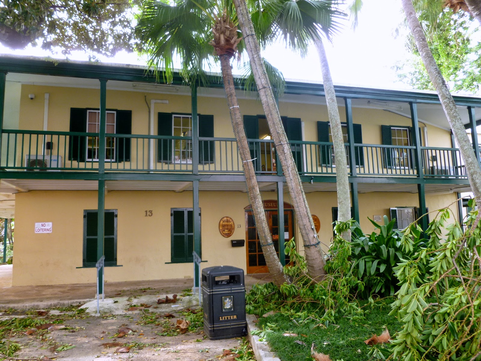
The Bermuda Historical Society Museum is located at 13 Queen Street, Hamilton, Bermuda.


Long Description:

Bermuda Historical Society Museum is a repository for a collection of important historical documents and artifacts about the history of Bermuda including a collection of coins and silver items made by local silversmiths.

Rubber Tree
The Georgian style house was once the home of William B Perot, who was Bermuda's first Post Master General. The two story structure has a wrap-around balcony, supported by green posts, on the second floor. An extension to the north side of the building is now the home of the Bermuda library. The front yard has a huge rubber tree planted by William Perot in 1847.

Hours of Operation: 

Monday through Saturday: 10 am to 2 pm
Sunday - Closed

Admission is free. Donations are accepted.

Thursday, November 27, 2014

Bermuda: Chandelier and Cedar Ceiling Beams - St. Peter's Church, St. George

Chandelier and Cedar Ceiling Beams
St. Peter's Church
St. George, Bermuda


N 32° 22.885 W 064° 40.655


Short Description: 

The interior of St. Peter's Church in St. George, Bermuda contains silver chandeliers and exposed cedar beams and posts.

Long Description:

St. Peter's Church in St. George, Bermuda is believed to be the oldest continually used Anglican church in the Western hemisphere. The original wooden church built 1612 was destroyed in a storm and replaced by the present church. In 2012, on the 400th anniversary of the church, Queen Elizabeth II gave the church the royal title "Their Majesties Chapell."

The church was rebuilt with native Bermuda cedar. The ceiling has and exposed lattice framework of cedar beams. Beneath the ceiling 4" by 4" cedar post span the length of the church. Suspended about 6.5' above the aisle floor from cedar posts are silver candlelit chandeliers. The symmetrical fixture has 12 arms joined to a central hub. Each arm holds a glass lantern and fitted with a candle.

The stamp was issued by Bermuda in 2012 as part of a set of four stamps commemorating the 400th anniversary of St. Peter's Church.

Wednesday, November 26, 2014

Bermuda: Clock Tower of St. Peter's Church - St. George

Clock Tower of St. Peter's Church
St. George, Bermuda


N 32° 22.899 W 064° 40.661


Short Description: 

The Clock Tower of St Peter's Church is an addition on the north corner of the church building in St. George, Bermuda.

Long Description:

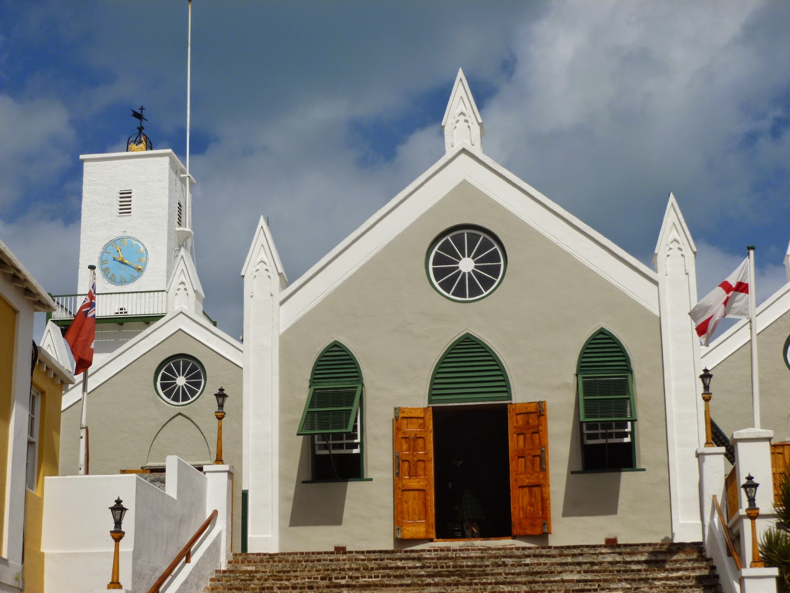
St. Peter's Church in St. George, Bermuda is believed to be the oldest continually used Anglican church in the Western hemisphere. The original wooden church built 1612 was destroyed in a storm and replaced by the present church. The church was extended in 1713 and the clock tower was added in the 19th century.

The tower is surrounded by an iron balcony just below the face of the clock. The clock face is light blue and the both the Roman numerals of the dial and the clock hands are gold. On top of the tower is a weather vane.

The stamp is part of a set of 4 stamps issued by Bermuda in 2012 to commemorate the 400th anniversary of St. Peter's Church.

Tuesday, November 25, 2014

Bermuda: Major General Sir William Reid - Hamilton

Major General Sir William Reid Obelisk
Hamilton, Bermuda


N 32° 17.582 W 064° 46.870


Short Description: 

An obelisk in memory of Major General William Reid is located on the east grounds of the Cabinet Building in Hamilton, Bermuda.

Long Description:

Major General Sir William Reid was a British officer who served as an engineer, governor, and scientist who made significant contributions to the study of tropical storms in the North Atlantic.

William Reid was born in Kinglassie, Fife, Scotland in 1791. He graduated from the Royal Military Academy in Woolwich and recieved a commissioned as a Lieutenant of Engineers in 1809. He served with Wellington's army in Lisbon and participated in Sir Edward Pakenham's unsuccessful attack on New Orleans in 1815, at the close of the War of 1812.

In 1831 he was sent to the Leeward Islands to oversee reconstruction after the Great Barbados hurricane. During his stay of 2.5 years he began his study of topical storms and, during his life, published two studies on the subject. He was elected a Fellow of the Royal Society in 1839.

In 1835 he served in the British Legion raised by the Queen Regent of Spain. He was then appointed by Queen Victoria to be the Governor of Bermuda, a position he held from 1839 to 1846. He was knighted in 1851 and promoted to Major General in 1856. He died in London in 1858 at age 67.

In 1861, a 25' high obelisk made of granite blocks was erected on the grounds of the Cabinet Building in his memory. The obelisk is surrounded by four steps and contains a bronze medallion with the left profile of Major General Sir William Reid on the front face. Below in very faint and weathered incised gold letters is the inscription:

ERECTED
A.D. MDCCCLXI
BY AUTHORITY OF THE LEGISLATURE
IN GRATEFUL REMEMBERANCE OF THE
PUBLIC SERVICES AND PRIVATE WORTH OF
MAJOR GEN SIR WILLIAM REID KCB
GOVERNOR OF BERMUDA FROM 1839 TO 1846
OBIIT 31 OCT. 1858 AE 67

Monday, November 24, 2014

Bermuda: Burial Ground for Slaves and Free Blacks - St. George

Burial Ground for Slaves and Free Blacks
St. George, Bermuda


N 32° 22.891 W 064° 40.672

Short Description: 

The burial ground for slaves and free blacks is located at the far western side of the grounds of St. Peter's Church in St. George, Bermuda.

Long Description:

St. Peter's Church in St. George, Bermuda is believed to be the oldest continually used Anglican church in the Western hemisphere. The original wooden church built 1612 was destroyed in a storm and replaced by the present church. The church was extended in 1713 and the clock tower was added in the 19th century.

Outside is a churchyard cemetery with a wall separating two graveyards. A walled area to the far west of the church was for slaves and free blacks while the one east of the wall was reserved for whites. The graveyard for slaves and free blacks is a significant site on the African Diaspora Heritage Trail of Bermuda which traces the legacy of Bermuda's slavery.

In 1698, St. George had a population of 1,124, one-third of whom were blacks who were mostly brought in from Africa as slaves. As the blacks converted to Christianity they became entitled to Christian burials. In the latter half of the 17th century the existing graveyard was extended to the west for the burial of both slaves and free blacks.


A bronze plaque on the wall on the left side of the entrance to the burial ground is inscribed:

BURIAL GROUND
FOR SLAVES
AND FREE BLACKS

PLAQUE ERECTED IN 1997 BY
THE ST. GEORGE'S CRICKET CLUB.


A bronze plaque on the wall on the right side of the entrance to the burial ground identifies it as an official UNESCO Slave Route Site. The central part of the plaque depicts a black family, a mother, father and two children walking hand in hand between a palm tree and a deciduous tree and above a stone wall. The plaque is inscribed:

THE BERMUDA DIASPORA HERITAGE TRAIL
{Globe With Bermuda Greatly Enlarged}
BERMUDA

OFFICIALLY DESIGNATED A UNESCO
SLAVE ROUTE PROJECT

St. Peter's Church
GRAVEYARD FOR SLAVES
AND FREE BLACKS

For nearly two Hundred years this
western extension of the 
church's graveyard
was the burial ground for the enslaved
or free Blacks of St. George Parish.

The burial ground stamp was issued by Bermuda in 2010 as part of a set of four stamps depicting sites on the UNESCO African Diaspora Heritage Trail. The stamp showing the UNESCO plaque was issued in by Bermuda in 2012 as part of a set of four stamps issued to commemorate the 400th anniversary of St. Peter's Church.

Sunday, November 23, 2014

Bermuda: Dockyard Gate - Royal Naval Dockyard, Sandys Parish

Dockyard Gate
Royal Naval Dockyard
Sandys Parish, Bermuda


N 32° 19.455 W 064° 50.131

Quick Description: 

The Dockyard Gate is located on Pender Road at the south entrance to the Royal Naval Dockyard in the west end of Bermuda.


Long Description:

The Royal Naval Dockyard was built in 1809 on the west end of Bermuda. Due to the fact that Bermuda is surrounded by reefs, it is the only location in Bermuda that is accessible to large cruise ships. At one time it was the largest British naval base outside the United Kingdom. It provided a vital strategic defense for British interests in the western Atlantic Ocean from the War of 1812 until after the Second World War. The area is defended by a fortress once known as the "Gibraltar of the West.”

Today the dockyard buildings have been restored and converted for commercial use. The buildings, that once housed the administration offices for the British Royal Navy, are now home to the Clock Tower Shopping Mall which contains boutique shops, arts and crafts studios and restaurants. The fortress is home to the National Museum of Bermuda.


A sign on the fence adjacent to the gate give the history of the Dockyard Gate. it is inscribed:


THE DOCKYARD GATE

Completed in 1842

Constructed during the reign of
Queen Victoria, this gate was
originally the innermost in line of
defensive gates protecting the land
approach to the Dockyard. The 
outlying bastion defenses and outer
gates were removed between 1901
and 1907 when the South Yard was
constructed. Above each pedestrian 
gate is a plaque displaying the Royal
Coat-of-Arms and a stone on its inner 
face records its construction date.

The stamp is part of a set of six stamps issued by Bermuda in 2004 showing views of the Royal Naval Dockyard.

Saturday, November 22, 2014

Bermuda: U.S. Armed Forces Commemorative Anchor - St. George

U.S. Armed Forces Commemorative Anchor
St. George, Bermuda


N 32° 22.773 W 064° 40.735


Short Description: 

A large Naval Stockless anchor commemorating the presence of the U.S. Armed Forces in Bermuda is located in a small park between Hunter's and Penno's Wharf in St. George, Bermuda.

Long Description:


This commemorative anchor is easily seen in a busy area near the ferry dock in St. George. A large 10' tall gray Naval Stockless anchor includes an artistically welded chain. A bronze plaque at ground level is inscribed:


This anchor is presented to
the Corporation of St. George's
on the 28th day of June 1995
By the United States Navy,
in commemoration of the U.S. Armed Forces
presence in Bermuda from 1941 - 1995
and in recognition of
the mutual alliance and continued friendship
with the citizens of St. George's

Friday, November 21, 2014

Bermuda: Victualling Yard Gateway - Royal Naval Dockyard, Sandys Parish

Victualling Yard Gateway
Royal Naval Dockyard
Sandys Parish, Bermuda


N 32° 19.631 W 064° 50.052


Quick Description: 

The Gateway to the Victualling Yard of the Royal Naval Dockyard is located on the west of of the walled compound and east of Dockyard Terrace in the west end of Bermuda.

Long Description:

Under Queen Elizabeth I, a Surveyor General of the Victuals was appointed to oversee contracts for food and other provisions for the Royal Navy. At dockyards throughout the British Empire the Victualling Board built breweries to supply beer, slaughterhouses to provide salted meat, and mills to create flour for the bakeries to produce biscuits for the ships under the quality control of the Board. These various facilities were consolidated into Victualling Yards.

The Royal Naval Dockyard was built in 1809 on the west end of Bermuda. Due to the fact that Bermuda is surrounded by reefs, it is the only location in Bermuda that is accessible to large cruise ships. At one time it was the largest British naval base outside the United Kingdom. It provided a vital strategic defense for British interests in the western Atlantic Ocean from the War of 1812 until after the Second World War. The area is defended by a fortress once known as the "Gibraltar of the West.”

Today the the area around the Victualling Yard of the Royal Naval Dockyard the Bermuda houses the Bermuda Craft Market and the Bermuda Arts Center.

The stamp is part of a set of six stamps issued by Bermuda in 2004 showing views of the Royal Naval Dockyard.

Thursday, November 20, 2014

Bermuda: Settlement of Bermuda/Admiral Sir George Somers - St. George, Bermuda

Settlement of Bermuda
Admiral Sir George Somers 
St. George, Bermuda


N 32° 22.917 W 064° 40.568


Quick Description:

A 20' tall obelisk contains a plaque commemorates the 300th anniversary of the settlement of Bermuda and its founder Admiral Sir George Somers. It it located at the entrance to Somers' Garden on Duke of York Street in St. George Bermuda.


Long Description:

A 20' high obelisk made of stone blocks commemorates the 300th anniversary of the settlement of Bermuda and honors the founder of Bermuda, Admiral Sir George Somers.

In 1609, Sir George Somers was appointed as Admiral of the Virginia Company's Third Supply relief fleet and was sent to the Jamestown colony in present day Virginia. On June 2, 1609, he sailed from Plymouth, England on the Sea Venture, the flagship of the seven-ship fleet. The ships encounter a storm on July 25th and were separated. The Sea Venture began to leak rapidly. On July 28th he spotted land, what is now Bermuda. He had to purposely drive his ship on a reef to prevent it from sinking. All of the 150 people on board were able to safely reach shore.

While ashore, the crew and passengers built a church and houses. This was the beginning of the settlement of Bermuda colony. Admiral Somers oversaw the construction of two small ships, the Deliverance and the Patience, from local timber and the wreckage of the Sea venture. They then and sailed to the original destination, the Jamestown Colony, to deliver much needed supplies. Thus enabling the survival of the colony.


The plaque contains a bas-relief sculpture of Admiral Sir George Somers above his ship the Sea Venture which is shown foundering on a reef. Below is the following inscription:


1609 - 1909

IN COMMEMORATION OF THE
SETTLEMENT OF THESE ISLANDS
ON THE 28TH DAY OF JULY 1609
AND 
IN HONOR OF ADMIRAL
SIR GEORGE SOMERS KT.
AT WHOSE INSTANCE LARGELY
THE SETTLEMENT WAS EFFECTED
THIS MEMORIAL
HAS BEEN ERECTED OUT OF A
GRANT MADE BY THE LEGISLATURE
OF THIS COLONY

Wednesday, November 19, 2014

Bermuda: City Hall Weather Vane - Hamilton, Bermuda

City Hall Weather Vane
Hamilton, Bermuda


N 32° 17.660 W 064° 47.130


Short Description: 

An unusual weather vane is located on the west side of the front of Hamilton City Hall located at 17 Church Street, Hamilton, Bermuda


Long Description:

The weather vane on Hamilton City Hall is an unusual and iconic feature of the building. The 91' high tower on the front of the building has a weather vane on the roof which is a replica of the ship the H.M.S. Sea Venture. In 1609, this ship was sailed by Sir George Somers the first settler of Bermuda. He purposely grounded the ship on the reef outside present day St. George to prevent the ship from sinking, thereby saving all the passengers and crew members aboard. These survivors then founded the first settlement in Bermuda. The beautiful blue, gold and black dial on the front of the tower has a single dial which reports the wind direction.


The stamp is part of a set of four stamps issued by Bermuda on June 24, 1974 to commemorate the 50th anniversary of Rotary International in Bermuda.