Monday, December 31, 2012

Holiday Displays: Bright Nights, Poinsettia Arch - Springfield, MA


Interesting Places I've Photographed
Bright Nights
Poinsettia Arch
Springfield, MA
Topic: Holiday Displays


GPS: N42° 05.069; W072° 33.908

Quick Description: 

Bright Nights is an annual display of holiday lighting in Forest Park in Springfield.

Long Description:

For 18 seasons the Bright Nights displays have become a top tourist attraction in New England. From the day before Thanksgiving to New Years Day Forest Park in Springfield is transformed into a fantasy-land of holiday light displays.

Visitors begin their tour by driving into the Sumner Street entrance to the park. The traffic winds it way through 2.5 miles of park road. Displays along the way include, in order:

Poinsettia Fantasy
American Flag
Spirit of the Season
Kwanzaa
Winter Garden
Seuss Land
Letters to Santa
Gift Stop
Snack Bar
Santa's Magical Forest and Cottage
Garden of Peace
Garden of Peace
Jurassic World
Noah's Ark
Victorian Village
Barney Mansion
Leaping Frog
Winter Woods
North Pole Village
Toy Land
Happy Holidays Springfield
Giant Poinsettia Candles

Bright Night Facts:

Number of Displays - 406
Number of Bulbs - 650,000
Days to Set Up - 60
Days to Take Down - 50

Sunday, December 30, 2012

Holiday Displays: Bright Nights, Sleigh Ride - Springfield, MA


Interesting Places I've Photographed
Bright Nights
Sleigh Ride
Springfield, MA
Topic: Holiday Displays


GPS: N42° 05.069; W072° 33.908

Quick Description: 

Bright Nights is an annual display of holiday lighting in Forest Park in Springfield.

Long Description:

For 18 seasons the Bright Nights displays have become a top tourist attraction in New England. From the day before Thanksgiving to New Years Day Forest Park in Springfield is transformed into a fantasy-land of holiday light displays.

Visitors begin their tour by driving into the Sumner Street entrance to the park. The traffic winds it way through 2.5 miles of park road. Displays along the way include, in order:

Poinsettia Fantasy
American Flag
Spirit of the Season
Kwanzaa
Winter Garden
Seuss Land
Letters to Santa
Gift Stop
Snack Bar
Santa's Magical Forest and Cottage
Garden of Peace
Garden of Peace
Jurassic World
Noah's Ark
Victorian Village
Barney Mansion
Leaping Frog
Winter Woods
North Pole Village
Toy Land
Happy Holidays Springfield
Giant Poinsettia Candles

Bright Night Facts:

Number of Displays - 406
Number of Bulbs - 650,000
Days to Set Up - 60
Days to Take Down - 50

Saturday, December 29, 2012

Holiday Displays: Bright Nights, Santa's Magical Forest Cottages - Springfield, MA


Interesting Places I've Photographed
Bright Nights
Santa's Magical Forest Cottages
Springfield, MA
Topic: Holiday Displays


GPS: N42° 05.069; W072° 33.908

Quick Description: 

Bright Nights is an annual display of holiday lighting in Forest Park in Springfield.

Long Description:

For 18 seasons the Bright Nights displays have become a top tourist attraction in New England. From the day before Thanksgiving to New Years Day Forest Park in Springfield is transformed into a fantasy-land of holiday light displays.

Visitors begin their tour by driving into the Sumner Street entrance to the park. The traffic winds it way through 2.5 miles of park road. Displays along the way include, in order:

Poinsettia Fantasy
American Flag
Spirit of the Season
Kwanzaa
Winter Garden
Seuss Land
Letters to Santa
Gift Stop
Snack Bar
Santa's Magical Forest and Cottage
Garden of Peace
Garden of Peace
Jurassic World
Noah's Ark
Victorian Village
Barney Mansion
Leaping Frog
Winter Woods
North Pole Village
Toy Land
Happy Holidays Springfield
Giant Poinsettia Candles

Bright Night Facts:

Number of Displays - 406
Number of Bulbs - 650,000
Days to Set Up - 60
Days to Take Down - 50

Friday, December 28, 2012

Holiday Displays: Bright Nights, Toy Land Arch - Springfield, MA

Interesting Places I've Photographed
Bright Nights
Toy Land Arch
Springfield, MA
Topic: Holiday Displays


GPS: N42° 05.069; W072° 33.908

Quick Description: 

Bright Nights is an annual display of holiday lighting in Forest Park in Springfield.

Long Description:

For 18 seasons the Bright Nights displays have become a top tourist attraction in New England. From the day before Thanksgiving to New Years Day Forest Park in Springfield is transformed into a fantasy-land of holiday light displays.

Visitors begin their tour by driving into the Sumner Street entrance to the park. The traffic winds it way through 2.5 miles of park road. Displays along the way include, in order:

Poinsettia Fantasy
American Flag
Spirit of the Season
Kwanzaa
Winter Garden
Seuss Land
Letters to Santa
Gift Stop
Snack Bar
Santa's Magical Forest and Cottage
Garden of Peace
Garden of Peace
Jurassic World
Noah's Ark
Victorian Village
Barney Mansion
Leaping Frog
Winter Woods
North Pole Village
Toy Land
Happy Holidays Springfield
Giant Poinsettia Candles

Bright Night Facts:

Number of Displays - 406
Number of Bulbs - 650,000
Days to Set Up - 60
Days to Take Down - 50

Thursday, December 27, 2012

Holiday Displays: Bright Nights, Barney Mansion - Springfield, MA


Interesting Places I've Photographed
Bright Nights
Barney Mansion
Springfield, MA
Topic: Holiday Displays


GPS: N42° 05.069; W072° 33.908

Quick Description: 

Bright Nights is an annual display of holiday lighting in Forest Park in Springfield.

Long Description:

For 18 seasons the Bright Nights displays have become a top tourist attraction in New England. From the day before Thanksgiving to New Years Day Forest Park in Springfield is transformed into a fantasy-land of holiday light displays.

Visitors begin their tour by driving into the Sumner Street entrance to the park. The traffic winds it way through 2.5 miles of park road. Displays along the way include, in order:

Poinsettia Fantasy
American Flag
Spirit of the Season
Kwanzaa
Winter Garden
Seuss Land
Letters to Santa
Gift Stop
Snack Bar
Santa's Magical Forest and Cottage
Garden of Peace
Garden of Peace
Jurassic World
Noah's Ark
Victorian Village
Barney Mansion
Leaping Frog
Winter Woods
North Pole Village
Toy Land
Happy Holidays Springfield
Giant Poinsettia Candles

Bright Night Facts:

Number of Displays - 406
Number of Bulbs - 650,000
Days to Set Up - 60
Days to Take Down - 50

Wednesday, December 26, 2012

Holiday Displays: Bright Nights, Seuss Land Arch - Springfield, MA


Interesting Places I've Photographed
Bright Nights
Seuss Land Arch
Springfield, MA
Topic: Holiday Displays


GPS: N42° 05.069; W072° 33.908

Quick Description: 

Bright Nights is an annual display of holiday lighting in Forest Park in Springfield.

Long Description:

For 18 seasons the Bright Nights displays have become a top tourist attraction in New England. From the day before Thanksgiving to New Years Day Forest Park in Springfield is transformed into a fantasy-land of holiday light displays.

Visitors begin their tour by driving into the Sumner Street entrance to the park. The traffic winds it way through 2.5 miles of park road. Displays along the way include, in order:

Poinsettia Fantasy
American Flag
Spirit of the Season
Kwanzaa
Winter Garden
Seuss Land
Letters to Santa
Gift Stop
Snack Bar
Santa's Magical Forest and Cottage
Garden of Peace
Garden of Peace
Jurassic World
Noah's Ark
Victorian Village
Barney Mansion
Leaping Frog
Winter Woods
North Pole Village
Toy Land
Happy Holidays Springfield
Giant Poinsettia Candles

Bright Night Facts:

Number of Displays - 406
Number of Bulbs - 650,000
Days to Set Up - 60
Days to Take Down - 50

Tuesday, December 25, 2012

Holiday Displays: Bright Nights, Spirit of the Season - Springfield, MA


Interesting Places I've Photographed
Bright Nights
Spirit of the Season
Springfield, MA
Topic: Holiday Displays


GPS: N42° 05.069; W072° 33.908

Quick Description: 

Bright Nights is an annual display of holiday lighting in Forest Park in Springfield

Long Description:

Spirit of the

For 18 seasons the Bright Nights displays have become a top tourist attraction in New England. From the day before Thanksgiving to New Years Day Forest Park in Springfield is transformed into a fantasy-land of holiday light displays.

Visitors begin their tour by driving into the Sumner Street entrance to the park. The traffic winds it way through 2.5 miles of park road. Displays along the way include, in order:

Poinsettia Fantasy
American Flag
Spirit of the Season
Kwanzaa
Winter Garden
Seuss Land
Letters to Santa
Gift Stop
Snack Bar
Santa's Magical Forest and Cottage
Garden of Peace
Garden of Peace
Jurassic World
Noah's Ark
Victorian Village
Barney Mansion
Leaping Frog
Winter Woods
North Pole Village
Toy Land
Happy Holidays Springfield
Giant Poinsettia Candles

Bright Night Facts:

Number of Displays - 406
Number of Bulbs - 650,000
Days to Set Up - 60
Days to Take Down - 50

Monday, December 24, 2012

Holiday Displays: Bright Nights, Happy Holidays - Springfield, MA


Interesting Places I've Photographed
Bright Nights
Happy Holidays Springfield
Springfield, MA
Topic: Holiday Displays
Happy Holidays


GPS: N42° 05.069; W072° 33.908

Quick Description: 

Bright Nights is an annual display of holiday lighting in Forest Park in Springfield.

Long Description:

For 18 seasons the Bright Nights displays have become a top tourist attraction in New England. From the day before Thanksgiving to New Years Day Forest Park in Springfield is transformed into a fantasy-land of holiday light displays.

Visitors begin their tour by driving into the Sumner Street entrance to the park. The traffic winds it way through 2.5 miles of park road. Displays along the way include, in order:

Poinsettia Fantasy
American Flag
Spirit of the Season
Kwanzaa
Winter Garden
Seuss Land
Letters to Santa
Gift Stop
Snack Bar
Santa's Magical Forest and Cottage
Garden of Peace
Jurassic World
Noah's Ark
Victorian Village
Barney Mansion
Leaping Frog
Winter Woods
North Pole Village
Toy Land
Happy Holidays Springfield
Giant Poinsettia Candles

Bright Night Facts:

Number of Displays - 406
Number of Bulbs - 650,000
Days to Set Up - 60
Days to Take Down - 50

Sunday, December 23, 2012

Immortalized in Lyrics: Stockbridge, MA - "Sweet Baby James" by James Taylor


Interesting Places I've Photographed
Stockbridge, MA
"Sweet Baby James" by James Taylor
Topic: Immortalized in Lyrics


GPS: N42° 16.931; W073° 18.659


Quick Description: 

Snow in the Berkshire town of Stockbridge and the highway from Stockbridge to Boston (Mass Pike) evokes "Sweet Baby James" by James Taylor.

Long Description:

Just the mention of the beautiful, quaint, typical New England village of Stockbridge evokes the haunting words and melody of James Taylor's "Sweet Baby James". Stockbridge was the home of American artist Norman Rockwell who produced numerous paintings, with an Americana theme, for the cover of the Saturday Evening Post. The main street in Stockbridge was one of his favorite subjects and made Stockbridge famous. The coordinates for this Waymark will take you to this quintessential small town American street in Stockbridge opposite the Stockbridge General Store. The snow on the ground adds to the ambiance. Stockbridge is Exit 1 on the Massachusetts Turnpike. Boston is about 130 miles to the east.

James Taylor was born in Massachusetts and he knows the geography. He has spent a lot of time in Stockbrige in Berkshire County. Every year he performs at the Tanglewood Music Festival.


Written and performed by James Taylor

"Well, there is a young cowboy he lives on the range
His horse and his cattle are his only companions
He works in the saddle and he sleeps in the canyons
Just waiting for Summer, his pastures to change

And as the moon rises he sits by his fire
Thinking about women and glasses of beer
And closing his eyes as the dogies retire
He sings out a song which is soft but it's clear
As if maybe someone could hear

(Chorus)
Goodnight you moonlight ladies
Rock-a-bye sweet baby James
Deep greens and blues are the colours I choose
Won't you let me go down in my dreams
And rock-a-bye sweet baby James

Now the first of December was covered with snow
And so was the turnpike from Stockbridge to Boston
Lord, the Berkshires seemed dream-like on account of that frosting
With ten miles behind me and ten thousand more to go

There's a song that they sing when they take to the highway
A song that they sing when they take to the sea
A song that they sing of their home in the sky
Maybe you can believe it if it helps you to sleep
But singing works just fine for me

- Chorus -
So, Goodnight you moonlight ladies
Rock-a-bye sweet baby James
Deep greens and blues are the colours I choose
Won't you let me go down in my dreams
And rock-a-bye sweet baby James"

Musician:
James Taylor

Name of Song: Sweet Baby James

Relevant Verse:
"Now the first of December was covered with snow
And so was the turnpike from Stockbridge to Boston
Lord, the Berkshires seemed dream-like on account of that frosting
With ten miles behind me and ten thousand more to go"

Saturday, December 22, 2012

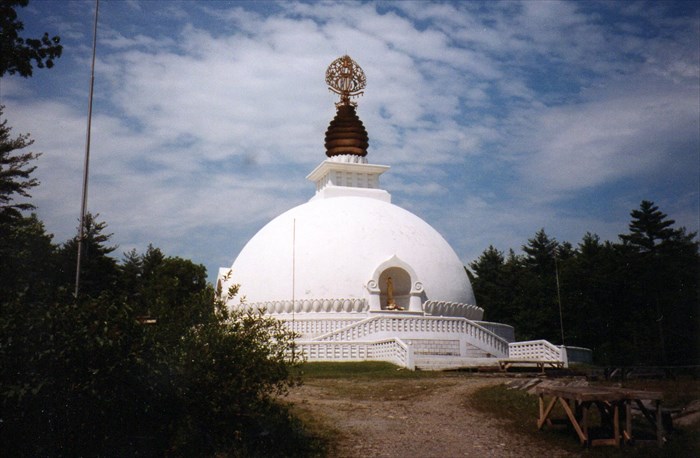
Peace Memorials: New England Peace Pagoda - Leverett, MA


Interesting Places I've Photographed
New England Peace Pagoda
Leverett, MA
Topic: Peace Memorials


GPS: N42° 29.922; W072° 29.471

Quick Description: 

The New England Peace Pagoda is the first Nipponzan-Myohoji Peace Pagoda to be built in the United States and was completed in 1986.


Long Description:

The New England Peace Pagoda is the fhe first Peace Pagoda in the United States. It sits on top of Cave Hill in Leverett. According to their website "The Pagoda is dedicated to the realization of universal peace on earth. It is a symbol of light in the darkness of the present day world, a visible prayer to awaken humankind to peace." The round stupa has four equidistant niches each of which has Buddhist shrine and a walkway leading up the the shrine.

A Peace Pagoda is a Buddhist stupa designed help focus and unite people in their search for world peace. Most have been built under the guidance of Nichidatsu Fujii (1885–1985), a Buddhist monk from Japan and founder of the Nipponzan-Myohoji Buddhist Order. Fujii was devoted his life to promoting non-violence. In 1947, he began constructing Peace Pagodas as shrines to World peace.

Nipponzan-Myohoji Peace Pagodas were first built in Hiroshima and Nagasaki. Now, more than eighty Peace Pagodas had been built around the world in Europe, Asia, and the United States.

Friday, December 21, 2012

Mosaic: Town of Charlemont


Interesting Places I've Photographed
Town of Charlemont Mosaic
Buckland, MA

Topic: Mosaic


GPS: N42° 36.328; W072° 44.451

Quick Description: 

The mosaic for Charlemont, MA is located at Christopher's Grinders on State Street.

Long Description:

The Deerfield River divides the village of Shelburne Falls. The east side is in the town of Shelburne and the west side is in the town of Buckland. The Shelburne Falls Mosaic Project was a community wide effort to celebrate the beauty of the rural area around Shelburne Falls. Artist Cynthia Fisher designed and created 10 3’ x 3’ mosaic panels that represent each of the hill-towns of this area of western Massachusetts. In addition, the project included two larger panels entitled "The Deerfield River" and the "American Indian Portrait".

The visitors center has a map showing the location the 12 mosaics. Each mosaic is labelled from 1 to 12. The Town of Charlemont is number 12. The mosaic for the Town of Charlemont depicts the Hail to Sunrise statue, Berkshire East Ski Area, Zoar white water rafting, Avery farm house, a covered bridge, and the year of incorporation - 1765.

Address:

Christopher's Grinders
55 State Street
Shelburne Falls, MA United States
01338

Thursday, December 20, 2012

Mosaic: Town of Rowe

Interesting Places I've Photographed
Town of Rowe Mosaic
Buckland, MA
Topic: Mosaic


GPS: N42° 36.240; W072° 44.475

Quick Description: 

The mosaic for Rowe, MA is located at the A brush With Fate Gallery building on State Street.

Long Description:
The Deerfield River divides the village of Shelburne Falls. The east side is in the town of Shelburne and the west side is in the town of Buckland. The Shelburne Falls Mosaic Project was a community wide effort to celebrate the beauty of the rural area around Shelburne Falls. Artist Cynthia Fisher designed and created 10 3’ x 3’ mosaic panels that represent each of the hill-towns of this area of western Massachusetts. In addition, the project included two larger panels entitled "The Deerfield River" and the "American Indian Portrait".

The visitors center has a map showing the location the 12 mosaics. Each mosaic is labelled from 1 to 12. The Town of Rowe is number 11. The mosaic for the Town of Rowe depicts a rural landscape with a Canada Goose, river otter, red-winged blackbird, sunfish, gazebo, and the year of incorporation - 1785.

Address:

A Brush Of Fate Gallery
20 State Street
Shelburne Falls, MA United States
01338

Wednesday, December 19, 2012

Mosaic: Town of Buckland


Interesting Places I've Photographed
Town of Buckland Mosaic
Buckland, MA
Topic: Mosaic


GPS: N42° 36.236; W072° 44.488

Quick Description: 

The mosaic for Buckland, MA is located at the Buckland Town Hall on State Street.

Long Description:
The Deerfield River divides the village of Shelburne Falls. The east side is in the town of Shelburne and the west side is in the town of Buckland. The Shelburne Falls Mosaic Project was a community wide effort to celebrate the beauty of the rural area around Shelburne Falls. Artist Cynthia Fisher designed and created 10 3’ x 3’ mosaic panels that represent each of the hill-towns of this area of western Massachusetts. In addition, the project included two larger panels entitled "The Deerfield River" and the "American Indian Portrait".

The visitors center has a map showing the location the 12 mosaics. Each mosaic is labelled from 1 to 12. The Town of Buckland is number 10. The mosaic for the Town of Buckland depicts a deer, portrait of Mary Lyon the founder of Mt. Holyoke College, the Buckland library, Shelburne Falls Trolley Museum trolley, Bridge of Flowers, cows, and the year of incorporation - 1779.

Address:

Buckland Town Hall
17 State Street
Shelburne Falls, MA United States
01338

Tuesday, December 18, 2012

Mosaic: Town of Conway


Interesting Places I've Photographed
Town of Conway Mosaic
Buckland, MA
Topic: Mosaic


GPS: N42° 36.306; W072° 44.493

Quick Description: 

The mosaic for Conway, MA is located at the McCuskers's Market building on State Street on the south side of the building.

Long Description:

The Deerfield River divides the village of Shelburne Falls. The east side is in the town of Shelburne and the west side is in the town of Buckland. The Shelburne Falls Mosaic Project was a community wide effort to celebrate the beauty of the rural area around Shelburne Falls. Artist Cynthia Fisher designed and created 10 3’ x 3’ mosaic panels that represent each of the hill-towns of this area of western Massachusetts. In addition, the project included two larger panels entitled "The Deerfield River" and the "American Indian Portrait".

The visitors center has a map showing the location the 12 mosaics. Each mosaic is labelled from 1 to 12. The Town of Conway is number 9. The mosaic for the Town of Conway depicts a mill stone, the town library, children on swings, a man riding behind a horse, and the year of incorporation - 1767.

Address:

MaCuskers Market
1-5 State Street
Shelburne Falls, MA United States
01338

Monday, December 17, 2012

Mosaic: Town of Ashfield


Interesting Places I've Photographed
Town of Ashfield Mosaic
Buckland, MA
Topic: Mosaic


N 42° 06.130 W 072° 44.500

Quick Description: 

The mosaic for Ashfield, MA is located at the Salmon Falls Artisan's Showroom on the west side of the building.

Long Description:
The Deerfield River divides the village of Shelburne Falls. The east side is in the town of Shelburne and the west side is in the town of Buckland. The Shelburne Falls Mosaic Project was a community wide effort to celebrate the beauty of the rural area around Shelburne Falls. Artist Cynthia Fisher designed and created 10 3’ x 3’ mosaic panels that represent each of the hill-towns of this area of western Massachusetts. In addition, the project included two larger panels entitled "The Deerfield River" and the "American Indian Portrait".

The visitors center has a map showing the location the 12 mosaics. Each mosaic is labelled from 1 to 12. The Town of Ashfield is number 8. The mosaic for the Town of Ashfield depicts the town hall steeple, making maple syrup, a farm scene, swimming in a lake, a roadside pumpkin stand, and the year of incorporation - 1765
.
Address:
Salmon Falls Artisan's Showroom
1 Ashfield Street
Buckland, MA United States
01338

Sunday, December 16, 2012

Mosaic: Town of Heath


Interesting Places I've Photographed
Town of Heath Mosaic
Shelburne, MA
Topic: Mosaic


GPS: N42° 36.224; W072° 44.390

Quick Description: 

The mosaic for Heath, MA is located on the west wall of the Blue Rock retaurant building on Bridge Street.

Long Description:

The Deerfield River divides the village of Shelburne Falls. The east side is in the town of Shelburne and the west side is in the town of Buckland. The Shelburne Falls Mosaic Project was a community wide effort to celebrate the beauty of the rural area around Shelburne Falls. Artist Cynthia Fisher designed and created 10 3’ x 3’ mosaic panels that represent each of the hill-towns of this area of western Massachusetts. In addition, the project included two larger panels entitled "The Deerfield River" and the "American Indian Portrait".

The visitors center has a map showing the location the 12 mosaics. Each mosaic is labelled from 1 to 12. The Town of Heath is number 7. The mosaic for the Town of Heath depicts a T-shirt with the Heath Fair logo, a farm scene with horses and a barn, a blueberry rake, a row of sunflowers, and the year of incorporation - 1785.

Address:
Blue Rock Restaurant
10 Bridge Street
Shelburne, MA United States
01370

Saturday, December 15, 2012

Mosaic: Deerfield River


Interesting Places I've Photographed
Deerfield River Mosaic
Shelburne, MA
Topic: Mosaic


GPS: N42° 36.189; W072° 44.381

Quick Description: 

Deerfield River Mosaic is located at the Young and Constantin Gallery on Deerfield Avenue in Shelburne Falls, MA

Long Description:

The Deerfield River divides the village of Shelburne Falls. The east side is in the town of Shelburne and the west side is in the town of Buckland. The Shelburne Falls Mosaic Project was a community wide effort to celebrate the beauty of the rural area around Shelburne Falls. Artist Cynthia Fisher designed and created 10 3’ x 3’ mosaic panels that represent each of the hill-towns of this area of western Massachusetts. In addition, the project included two larger panels entitled "The Deerfield River" and the "American Indian Portrait".

The visitors center has a map showing the location the 12 mosaics. Each mosaic is labelled from 1 to 12. The Deerfield River Mosaic is number 6. The mosaic depicts wildlife, recreation, culture and use of the Deerfield River. Wildlife includes the great blue heron, endangered golden winged warbler, and wood turtle. Culture is represented by the Frog and Flower Parade. Recreation is represented by a fisherman. The Salmon Falls Dam provided power and downstream flood control.

Address:
Young and Constantin Gallery
4 Deerfield Avenue
Shelburne Falls, MA United States
01370

Friday, December 14, 2012

Mosaic: American Indian Portrait


Interesting Places I've Photographed
American Indian Portrait Mosaic
Shelburne, MA
Topic: Mosaic


GPS: N42° 36.211; W072° 44.380

Quick Description: 

The American Indian Portrait mosaic is located on the Deerfield Avenue side of the Rod & Gun Club building .

Long Description:

The Deerfield River divides the village of Shelburne Falls. The east side is in the town of Shelburne and the west side is in the town of Buckland. The Shelburne Falls Mosaic Project was a community wide effort to celebrate the beauty of the rural area around Shelburne Falls. Artist Cynthia Fisher designed and created 10 3’ x 3’ mosaic panels that represent each of the hill-towns of this area of western Massachusetts. In addition, the project included two larger panels entitled "The Deerfield River" and the "American Indian Portrait".

The visitors center has a map showing the location the 12 mosaics. Each mosaic is labelled from 1 to 12. The American Indian Portrait is number 5. The mosaic depicts the life and culture of three Native American tribes that inhabited this area: the Mohegan, Mahican and Pocumtuck. The central motif shows traditional fishing on the Salmon Falls area of the Deerfield River, a place today known as the potholes. The Atlantic Salmon is shown in the lower right corner. There is also a wigwam, canoes, and Native Americans dying of disease.

Address:
Rod and Gun Club
15 Bridge Street
Shelburne Falls, MA United States
01370

Thursday, December 13, 2012

Mosaic: Town of Shelburne


Interesting Places I've Photographed
Town of Shelburne Mosaic
Shelburne, MA
Topic: Mosaic


GPS:N42° 36.215; W072° 44.313

Quick Description: 

The mosaic for Shelburne, MA is located at the Memorial Hall in Shelburne Falls.

Long Description:

The Deerfield River divides the village of Shelburne Falls. The east side is in the town of Shelburne and the west side is in the town of Buckland. The Shelburne Falls Mosaic Project was a community wide effort to celebrate the beauty of the rural area around Shelburne Falls. Artist Cynthia Fisher designed and created 10 3’ x 3’ mosaic panels that represent each of the hill-towns of this area of western Massachusetts. In addition, the project included two larger panels entitled "The Deerfield River" and the "American Indian Portrait".

The visitors center has a map showing the location the 12 mosaics. Each mosaic is labelled from 1 to 12. The Town of Shelburne is number 4. The mosaic for the Town of Shelburne depicts the landscape and village of Shelburne Falls, the Bridge of Flowers over the Deerfield River, and the year of incorporation - 1775. It also pay homage to Shelburne Falls artist Judith Russell. The plaque below gives the date 1768 which is not the year of incorporation but the year Shelburne became organized as a district.

Address:
Memorial Hall
51 Bridge Street
Shelburne Falls, MA United States
01370

Wednesday, December 12, 2012

Mosaic: Town of Plainfield


Interesting Places I've Photographed
Town of Plainfield Mosaic
Shelburne, MA
Topic: Mosaic


GPS: N42° 36.225; W072° 44.314

Quick Description: 

The mosaic for Plainfield, MA is located at the Baker Pharmacy the Baker Avenue side.

Long Description:

The Deerfield River divides the village of Shelburne Falls. The east side is in the town of Shelburne and the west side is in the town of Buckland. The Shelburne Falls Mosaic Project was a community wide effort to celebrate the beauty of the rural area around Shelburne Falls. Artist Cynthia Fisher designed and created 10 3’ x 3’ mosaic panels that represent each of the hill-towns of this area of western Massachusetts. In addition, the project included two larger panels entitled "The Deerfield River" and the "American Indian Portrait".

The visitors center has a map showing the location the 12 mosaics. Each mosaic is labelled from 1 to 12. The Town of Plainfield is number 3. The mosaic for the Town of Plainfield depicts the town yesterday and today. Yesterday depicts a woman churning butter, a farm house, and sheep. Today depicts recreational opportunities - horseback riding, forest scene with ruin, canoeing, and the year of incorporation - 1775.

Address:
Baker's Pharmacy
52 Bridge Street
Shelburne Falls, MA United States
01370

Tuesday, December 11, 2012

Mosaic: Town of Colrain


Interesting Places I've Photographed
Town of Colrain Mosaic
Shelburne, MA
Topic: Mosaic


GPS: N42° 36.213; W072° 44.294

Quick Description: 

The mosaic for Colrain, MA is located at the Gypsy Apple cafe on Bridge Street.

Long Description:

The Deerfield River divides the village of Shelburne Falls. The east side is in the town of Shelburne and the west side is in the town of Buckland. The Shelburne Falls Mosaic Project was a community wide effort to celebrate the beauty of the rural area around Shelburne Falls. Artist Cynthia Fisher designed and created 10 3’ x 3’ mosaic panels that represent each of the hilltowns of this area of western Massachusetts. In addition, the project included two larger panels entitled "The Deerfield River" and the "American Indian Portrait".

The visitors center has a map showing the location the 12 mosaics. Each mosaic is labelled from 1 to 12. The Town of Colrain is number 2. The mosaic for the Town of Colrain depicts several important features of the town: the town center, the first flag to fly over a public school, a farm, a pine tree and lake, a schoolhouse, an American Flag, a puma, and the year of incorporation - 1761.

Address:
63 Bridge Street
Shelburne Falls, MA United States
01370

Monday, December 10, 2012

Mosaic: Town of Hawley


Interesting Places I've Photographed
Town of Hawley Mosaic
Shelburne, MA
Topic: Mosaic


GPS: N42° 36.213; W072° 44.243

Quick Description: 

The mosaic for Hawley, MA is located at the visitors center in Shelburne Falls, MA

Long Description:

The Deerfield River divides the village of Shelburne Falls. The east side is in the town of Shelburne and the west side is in the town of Buckland. The Shelburne Falls Mosaic Project was a community wide effort to celebrate the beauty of the rural area around Shelburne Falls. Artist Cynthia Fisher designed and created 10 3’ x 3’ mosaic panels that represent each of the hill-towns of this area of western Massachusetts. In addition, the project included two larger panels entitled "The Deerfield River" and the "American Indian Portrait".

The visitors center has a map showing the location the 12 mosaics. Each mosaic is labelled from 1 to 12. The Town of Hawley is number 1. The mosaic for the Town of Hawley depicts several important features of the town: the Hawley Bog Preserve, the Mohawk Trail State Forest, the Dubuque State Forest, the Beehive Kiln, and the year of incorporation - 1792.

Address:
75 Bridge Street
Shelburne Falls, MA United States
01370

Sunday, December 9, 2012

Civil Rights Memorials: Sojourner Truth and the NAEI - Florence, MA


Interesting Places I've Photographed
Sojourner Truth
and the 
Northampton Association of Education and Industry
Florence, MA
Topic: Civil Rights Memorials


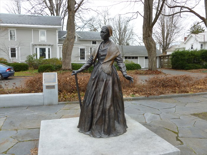
Sojourner Truth

            N 42° 19.919 W 072° 40.475

Quick Description: 

A site dedicated to Sojourner Truth and the Northampton Association of Education and Industry is located in Sojourner Truth Memorial Park on Park Street in the Florence section of Northampton.

Long Description:

Sojourner Truth Memorial Park contains a statue of the civil rights activist. In addition the park contains three monuments with plaques. The first, at the entrance, tells the story of the Utopian community, The Northampton Association of Education and Industry, where Sojourner Truth was a key member. Two other plaques, near the statue, give the biography of Sojourner Truth.

The life-size bronze figure of Sojourner Truth is shown standing in the middle of a 6' square by 1' high granite base. She is wearing a period head covering, long scarf and floor length dress. She holds a walking stick, an an angle, by the palm of her right hand. The stick rest on the ground behind her right foot.
The statue was created by Thomas Jay Warren and was a gift from the sculptor to the City of Northampton. The statue was installed in the park in 2002.

Below the first biographical plaque is a plaque about the statue which is inscribed:


A gift to the City of Northampton
2002
Sculptor Thomas Jay Warren
Landscape Architect, Dening Design Associates

Two plaques are inscribed with Sojourner Truth's biography:

Sojourner Truth was born a slave named Isabella in upstate new York in 1797. She worked for a series of five masters while raising five children. When slavery ended in New York in 1827, she settled in New York City. A deeply religious woman, Isabella took the name Sojourner Truth after God spoke to her. She was 46 years old when she set out walking and preaching through Long Island and Connecticut. Eventually she reached Massachusetts and joined the Northampton Association of Education and Industry.

From her home here in what is now Florence, Truth broadened her mission and began speaking out for the abolition of slavery and for women's rights.

Continued on second plaque:

After the demise of the Northampton Association, Samuel L. Hill and others founded the factory village of Florence. With Hill's help, Sojourner Truth bought her own home on Park Street. Unable to read or write, Truth dictated her story to a neighbor. The Narrative of Sojourner Truth was published in 1850. She became well-known as an orator, singer, evangelist, abolitionist and reformer, selling her Narrative and photographs of herself throughout the nation.
Although she moved to Battle Creek, Michigan in 1857, she was fondly remembered in Florence, where her wisdom and wit were especially valued. Samuel Hill noted that his long acquaintance with Sojourner truth confirmed her "title to the name you have chosen, and its record in humanity's 'Book of Life.'"

As you enter the plaza there is a monument with the history of the Northampton Association of Education and Industry, which played an important role in the life of Sojourner Truth. It is inscribed:

The Northampton Association of Education and Industry was one of a number of Utopian communities that arose in the 1840's Its members were ardent abolitionists who believed in equality for blacks and women. The Association served as a haven for radical reformers and was a stop on the Underground Railroad. Sojourner Truth and David Ruggles, a well-known African-American abolitionist, were valued members. Engaged in silk manufacture and other economic activities, the Association paid all its workers equally. Fredrick Douglass remembered its people as the "most democratic I have ever met. There was no high, no low, no masters, no servants, no white, no black."

In 1993, the Committee for Northampton was formed to dismantle racism and to call for social justice. This memorial was inspired by the life of Sojourner Truth and the interracial community to which she belonged. Welcome to this site and to this cause. 

Saturday, December 8, 2012

Beatlemania: John Lennon Peace Wall - Prague, Czech Republic


Interesting Places I've Photographed
John Lennon Peace Wall
Prague, Czech Republic
Topic: Beatlemania


GPS: N50° 05.162; E014° 24.416


Quick Description: 

The John Lennon Peace Wall is in Prague, Czech Republic near the French Embassy.

Long Description:

The John Lennon Peace Wall represented not only a memorial to John Lennon and his ideas for peace, but also a monument to free speech and the non-violent rebellion of Czech youth against the communist regime. It was an ongoing battle between the Czech people who continually wrote their messages and the communist police who cleaned the wall. Many believe that the John Lennon Peace Wall helped inspire the non-violent Velvet Revolution that led to the fall of Communism in the former Czechoslovakia in 1989.

In 1998 the wall had to go through reconstruction of its crumbling facade now it is covered in messages of love and peace. The original portrait of Lennon is long lost under the layers of new paints but if you look hard enough you can still find tributes to Lennon and a yellow submarine!

The wall is located at Velkoprevorske Namesti, Mala Strana, and is owned by the Knights of the Maltese Cross, who allowed graffiti to continue. The wall continues to evolve as messages are added, overwritten and removed.

Friday, December 7, 2012

WWII Monuments: Milford CT


Interesting Places I've Photographed
World War II Monument
Milford, CT
Topic: WWII Monuments


GPS: N41° 13.315; W073° 03.461

Quick Description: 

Milford's World War II Monument is located on the Milford Green in the downtown area of Milford.

Long Description:


Milford's World War II Monument was dedicated by the City of Milford on August 13, 1995 as a tribute to the men and women who served their country in time of need and to commemorate the 50th anniversary of the end of World War II. The monument is a bronze sculpture of five figures position on a large granite base. The sculptor of the monument is John Blair, a graduate of the Pennsylvania Academy of Fine Arts in Philadelphia.

Five members of the military, representing various branches, are shown in action. Two figures are facing west and three are facing east. A soldier (Marine) is facing west while kneeling on his left knee. He is carrying an assault weapon and in his left hand on the trigger and his right hand near the barrel. He is wearing suspenders and has a canteen on his left hip. Behind him stands an aviator (Army Air Corp) wearing a flight helmet with goggles on his head. A parachute pack hangs off his shoulders and down his back. Behind the aviator and facing east is a WAC (Women's Army Corp). She is smartly dressed with a skirt, jacket, and cap and appears to be wearing silk stocking on her legs. To her right is a sailor (Navy). He is standing upright while wearing a life jacket over his uniform. At the east side is another soldier (Army). He is kneeling on his right knee with his butt resting on the back of his right leg. In his hands he is holding a rifle with his right hand on the trigger. A canteen hangs from his belt on his left side.

On the north and south sides of the base there are identical plaques which are inscribed:

DEDICATED TO ALL
WHO SERVED
1941 {Honorable Discharge Emblem} 1945
WORLD WAR II

On the ground at the east end of the base is a plaque with the names of the monument committee. The plaque has inscribed the following names:

Memorial Committee
------------------
William J. Moffet – President
Leopold Bisson
Burt Bond
Wayne Carson
Mario Ditroia
Ernest Dubois
Don Elliott
Edward Filanowski
George Frye
Cornelius Heyse, Jr.
Alan Jepson
Mike Kivic
Paul A. Lahr, Jr.
Dayle Leland
George J. Martelon
Elvera McGuire
Daniel T. Meisenheimer, Jr.
Jim Merrill
Eleanor Myers
Harold Murray, Jr.
Peter Penkala
John Poole
Sigismund (Ziggy) Skibek
Winthrop (Pink) Smith
Salvatore Vitale
Joseph Von Dietsch
Marcus White
Don Wright
And All Who Served


The details I received from City of Milford officials about this monument reveal that there is a time capsule underneath the bronze ground plaque. It contains memorabilia and photographs of the World War II years and of 1995. The capsule will be opened on August 13, 2045, on the 100th anniversary of the end of World War II.

Thursday, December 6, 2012

Angel of Hope Statue: St. Anne Shrine - Sturbridge, MA

Angel of Hope Statue
St. Anne Shrine
Sturbridge, MA


GPS: N42° 07.091; W072° 06.817
Quick Description: 

An Angel of Hope statue is located at the St. Anne Shrine in the Fiskdale section of Sturbridge, MA. The shrine is located at 16 Church Street just north of Route 20.

Long Description:

St. Anne Shrine is a 35 acre sanctuary for spiritual renewal. It is located within the Diocese of Worcester and is operated by the Augustinians of the Assumption religious order. The Angel of Hope statue is located at the end of a short shaded path on the east side of the shrine.

The Angel of Hope statue installed on the grounds of the St. Anne Shrine sits on a 3' high rough cut granite base. The front and the back have an polished recessed panel with the following inscriptions:

Front:
Our
CHILDREN
Angels of Hope
Cherished and
Forever Loved


Back:


Christmas Box Angel
Dedicated
September 15, 2007

Annual
Candlelight Vigil
December 6th
At 7:30 P.M.

A nearby plaque tells the story behind the Angel of Hope statues.


THE CHRISTMAS BOX STORY

The Angel of Hope was inspired by Richard Paul Evans' national
bestseller, The Christmas Box. It is a story of a woman who
mourns the loss of her child at the base of an angel
monument. the monument that the fictional tale speaks of
once existed but was destroyed by floods in 1984. Evans
commissioned a new angel in response to reports of parents
seeking out the angel as a place to grieve and heal. The
monument lies in a cemetery in Salt Lake City, UT. The angel
was dedicated on December 6, 1994 - corresponding with the
date of the child's death in The Christmas Box.

The sculpture is the creation of a father and son from Salt
Lake City, Ortho and Jared Fairbanks. It was molded according
to the description in Evans' book.

The Angel of Hope monument was brought to central Mass to
support parents who have lost a child of any age for any
reason. The monument was dedicated on September 15, 2007.

The angel's face is that of the child's, its arms raised as a child
to be lifted, in its wings are hope.

A candlelight vigil is held each year on December 6 at 7:00 P.M.
Children's Day. We invite grieving families to unite and find
strength, comfort and solace with each other. A white
flower may be placed at the base of the statue in memory of a
loved one.

May you attain some peace and healing in her presence.

Wednesday, December 5, 2012

Abraham Lincoln: A Welcome Conversation - East Hartford, CT


Interesting Places I've Photographed
A Welcome Conversation
East Hartford, CT
Topic: Abraham Lincoln

A Welcome Conversation
Plaque
GPS: N41° 46.011; W072° 39.826


Quick Description: 

A Welcome Conversation is the title of a sculpture located at the Lincoln Financial Sculpture Walk at Riverfront in East Hartford, CT.

Long Description:

Sixteen abstract and traditional sculptures related to the life and legacy of Abraham Lincoln are installed along the Lincoln Financial Sculpture Walk at Riverfront in Hartford and East Hartford.

This sculpture by Don Sottile depicts a Abraham Lincoln as a young man in his early 20's and celebrates his ability to relate to townspeople. Lincoln is sitting on a rock and invites the viewer to sit on an adjacent rock to have a conversation.

A plaque adjacent to the sculpture is inscribed:

{Profile of Lincoln}
Lincoln
Financial
Sculpture
Walk at
Riverfront

{five wavy lines}

A Welcome Conversation
Don Sottile, 2006

"Every man is said to have his peculiar
ambition. Whether it be true or not, I can say
for one that I have no other so great as that
of being truly esteemed of my fellow men ..."


In his early 20's, Abraham Lincoln settled in the village of
New Salem, Illinois. he gained immediate attention as a
hard worker and natural leader and was known for his wit
and honesty. As the town's postmaster, he was always
ready to please his customers and would go out of his way
to meet their needs, sometime walking miles to deliver
mail. He also was viewed as the town's storyteller and
would entertain townspeople with jokes, tales and
self-effacing campaign speeches. His colorful phrases and
backwoods humor helped him connect with people as well
as win their trust and admiration.


The Lincoln Financial is an insurance company based in Philadelphia with offices in Hartford.


Tuesday, December 4, 2012

Abraham Lincoln: Career Column - East Hartford, CT


Interesting Places I've Photographed
Career Column
East Hartford, CT
Topic: Abraham Lincoln
Career Column - Front

The Career Column - Back
Plaque
N 41° 46.122 W 072° 39.812


Quick Description: 

Career Column is the title of a silhouette cut-out sculpture located at the Lincoln Financial Sculpture Walk at Riverfront in East Hartford, CT.

Long Description:

Sixteen abstract and traditional sculptures related to the life and legacy of Abraham Lincoln are installed along the Lincoln Financial Sculpture Walk at Riverfront in Hartford and East Hartford.

The Career Column recounts the many positions that Abraham Lincoln held during is life. A 7' tall rectangular column has seven cut out images, four on one side three on the other, of Lincoln engaged in various professions. The following professions are listed on the narrow sides: lawyer, politician, postmaster, storekeeper, inventor, surveyor, and circuit judge.

A plaque adjacent to the sculpture is inscribed:

{Profile of Lincoln}
Lincoln
Financial
Sculpture
Walk at
Riverfront

{five wavy lines}


Career Column
Gar Waterman, 2005


"The way for a young man to rise is to improve himself in every way he can."

Abraham Lincoln's road to the White House was paved
with a variety of careers. In addition to farming, he
worked as a rail-splitter, floatboatman, and manual laborer.
Later, he was hired as a clerk for a store in New Salem,
Illinois and soon opened his own store. When the Black
Hawk War broke out in 1832, Lincoln captained a
volunteer company. After serving as postmaster and
deputy surveyor, he was elected to the state legislature in
1834 and began to study law. he received his law
license in 1836 and went into practice in 1837. Lincoln was
reelected to the legislature in 1836, 1838 and 1840 and was
elected to Congress in 1846. After serving in Congress,
Lincoln set aside his political aspirations to practice law,
but the repeal of the Missouri Compromise (allowing the
expansion of slavery) ignited a passion that ultimately led
to his presidential run in 1860.


The Lincoln Financial is an insurance company based in Philadelphia with offices in Hartford.


Monday, December 3, 2012

Abraham Lincoln: Transcontinental - East Hartford, CT


Interesting Places I've Photographed
Transcontinental
East Hartford, CT
Topic: Abraham Lincoln
Transcontinental
Plaque
GPS: N41° 46.029; W 072° 39.851


Quick Description: 

Transcontinental is the title of an abstract sculpture located at the Lincoln Financial Sculpture Walk at Riverfront in East Hartford, CT.

Long Description:

Sixteen abstract and traditional sculptures related to the life and legacy of Abraham Lincoln are installed along the Lincoln Financial Sculpture Walk at Riverfront in Hartford and East Hartford. Lincoln Financial is an insurance company based in Philadelphia with offices in Hartford.

Lincoln was a forceful advocate for the construction of the transcontinental railroad. During his presidency he signed into law the Pacific Railway Acts in 1862 and 1863, which laid the legal groundwork for fulfilling this aspiration. This abstract sculpture by Carol Eisner consists of three curved sections of steel, suggestive of railroad tracks. The center piece forms an arch with a spiral piece below and a semi-oval above. The composition forms a open hemisphere about 6' in diameter.

A plaque, adjacent to the sculpture, is inscribed:

{Profile of Lincoln}
Lincoln
Financial
Sculpture
Walk at
Riverfront

{five wavy lines}

Transcontinental
Carol Eisner, 2005

"No other improvement that reason will
justify us in hoping for, can equal in utility
the railroad."


Early in his career as an Illinois state legislator, Lincoln
understood the great economic and military advantage a
transcontinental railroad would provide as well as the
sense of unity it would the burgeoning country.
he envisioned a time when the country would be linked
from coast to coast by a national railroad system.
Lincoln's presidential platform in 1860 included a
commitment to build a railroad to the Pacific and he
signed the Pacific Railway Acts in 1862 and 1863.
Unfortunately, the president never lived to see the
railroad completed, but his body was carried by train from
Washington, D.C. to Springfield, Ill. for burial in May
1865.


Sunday, December 2, 2012

Abraham Lincoln: The Circuit Rider - East Hartford, CT


Interesting Places I've Photographed
The Circuit Rider
East Hartford, CT
Topic: Abraham Lincoln
The Circuit Rider
Plaque
GPS: N41° 45.783; W 072° 39.787

Quick Description: 

The Circuit Rider is the title of a wire-frame sculpture of Lincoln's horse, Old Tom, located at the Lincoln Financial Sculpture Walk at Riverfront in East Hartford, CT.

Long Description:

Sixteen abstract and traditional sculptures related to the life and legacy of Abraham Lincoln are installed along the Lincoln Financial Sculpture Walk at Riverfront in Hartford and East Hartford. Lincoln Financial is an insurance company based in Philadelphia with offices in Hartford.

Lincoln spent more than 20 years in the saddle as a circuit-riding lawyer in the 8th Judicial District of Illinois. A wire-frame sculpture of his horse, Old Tom, by Peter Busby is near a plaque that tell the story of his days as the circuit rider.

The plaque begins with a quote from Lincoln about the value of compromise and is inscribed:


{Profile of Lincoln}

Lincoln
Financial
Sculpture 
Walk at
Riverfront
{five wavy lines}

The Circuit Rider
Peter Busby, 2007

"Discourage litigation. Persuade your
neighbors to compromise whenever you can."


At 6'4", Lincoln was nearly a foot taller than the average
American man in the mid-1800s and, although very lean,
he had great physical strength built through years of
manual labor as a farmer, boatman and rail-splitter. His
strength and endurance were great assets when he became 
a lawyer and spent nearly three months each spring and 
fall traveling the 11,000 square miles that comprised the
old Eight Judicial Circuit in Central Illinois arguing
cases in local county courthouses. Lincoln became a bit of
a celebrity, and farmers and local townspeople would
gather to listen to his stories and watch his prowess in the
courtroom. he and his horse, (sic) Old Bob, were welcomed
into their homes, offered food and places to sleep. Most
lawyers would ride the circuit for a few years and then
establish a law practice in their hometowns, but Lincoln
rode the circuit for more than 20 years. Many of these 
courthouses are still standing today and are marked with
commemorative plaques.