Monday, November 13, 2017

Simulacra: Old Man in The Mountain - Corner Brook, Newfoundland, Canada

Old Man in The Mountain
Corner Brook, Newfoundland
Canada


N 48° 56.995 W 057° 52.543


Short Description: 

The Old Man in The Mountain is located in a cliff face called Breakfast Head north of the city of Corner Brook. A roadside viewpoint off Route 1, the Trans Canada Highway, provides an interpretative display on where to look.


Long Description:

An image in a cleft on the cliff called Breakfast Head contains the face of a craggy old man who is thought by some to be, perhaps, a fisherman or a pirate. The old main has a long crooked nose, deep set eyes, a beard, and appears to be wearing a pointed knit-type hat.

Sunday, November 12, 2017

Historic Figure: Captain James Cook - Corner Brook, Newfoundland, Canada

Captain James Cook
Corner Brook, Newfoundland
Canada


N 48° 57.270 W 057° 57.780


Quick Description: 

A statue of British Royal Navy Captain, explorer, navigator, and cartographer Captain James Cook is located at the Captain James Cook Historical Site in Corner Brook, Newfoundland.

Long Description:

The Captain James Cook Historical Site is located on a hilltop overlooking the city of Corner Brook and the Bay of Islands. In the center of the overlook is a 7' high bronze statue of Captain James Cook. He is dressed in the attire of an 18th century British Naval captain with a high collar jacket, buttoned vest, ruffled shirt sleeves, and buckle shoes. He is standing on an 18" high rock base and holding a sexton with both hands.


A nearby historical marker describes the accomplishments of Captain James Cook in Newfoundland in English and French. The English version is inscribed:

                  CAPTAIN JAMES COOK, R.N.

From 1763 to 1767 Captain James Cook, R.N. directed a
survey embracing the greater part of the coast of New-
foundland. The charting of this coastline was the first 
scientific, large scale, hydrographic survey to use precise
triangulation to establish outlines. It produced a
collection of charts which remained a standard for a century.
The choice of Cook to carry out Pacific exploration was
the result of his success in Newfoundland. Cook's visit to
the area on his ascent of the Humber as far as Deer Lake
was part of the first serious attempt to delineate the in-
land topography of Newfoundland.

James Cook was on November 7, 1728 (N.S.) in the village of Marton in Yorkshire, England. As a teenager studied algebra, geometry, trigonometry, navigation, and astronomy as a merchant ship apprentice. He rose through the merchant navy ranks and in 1755 joined the British Royal Navy as an able seaman and, in 1757, a master's mate aboard the HMS Eagle.

During the Seven Years' War, he served in North America and participated in the capture the Fortress of Louisbourg from the French, the siege of Quebec City, and the Battle of the Plains of Abraham in 1759. Thereafter, because of his talent surveying and cartography, he was assigned to map the coast of Newfoundland. The success in this endeavor led to his assignment to command a scientific voyage to the Pacific Ocean aboard the Royal Navy research vessel HMS Endeavor.

Between 1768 and 1779 he made three voyages of discover throughout the Pacific Ocean. He was killed in a skirmish with native Hawaiians on February 14, 1779 and was formally buried at sea.

Saturday, November 11, 2017

Waterfall: Montmorency Falls - - Beauport, PQ, Canada

Montmorency Falls
Beauport, PQ, 
Canada


N 46° 53.183 W 071° 08.672


Short Description: 

Montmorency Falls is located with Montmorency Falls Park at the boundary of the between the boroughs of Beauport and Boischatel in the northeast part of Quebec City PQ, Canada.

Long Description:

Montmorency Falls is the highest waterfall in the Province of Quebec. At 284 feet high, it is much taller than Niagara Falls (167'). It is located on the Montmorency River near its confluence with the St. Lawrence River. The 151' wide waterfall is characterized as a cataract type falls but when the water is high is appears to be a single drop fall.

A stairway on the right side of the falls will take visitors to a view point near the top of the falls. The enormous amount of spray coming from the falls makes for a soggy experience. The falls are best viewed from Parc de la Chute-Montmorency where a cable car can take visitors to the top of the falls. Also, a zip line operates during the summer months.

From Parking fee is $7.05 per car from November 1 to April 29 and $10.57 the remainder of the year.

Friday, November 10, 2017

Fountain: Queen Victoria Diamond Jubilee Fountain - Halifax, NS, Canada

Queen Victoria 
Diamond Jubilee Fountain 
Halifax, NS
Canada


N 44° 38.590 W 063° 35.000


Short Description: 

Queen Victoria Diamond Jubilee Fountain is located in the northwest quadrant of the Halifax Public Garden in Halifax, Nova Scotia.


Long Description:

To celebrate the 60th anniversary of Queen Victoria's ascent to the throne of the United Kingdom the Garden Commissioners erected a large ornate fountain in Halifax Public Garden. The fountain is designed in the classical style with a central portion containing, a column decorated with cherubs sitting on sea serpents and an upper basin topped with a statue of the nymph Egeria dressed in classical robes. Egeria is pouring water from an urn into the upper basin. Water pours out from the upper basin from a series of ornate gargoyle spouts encircling the rim and falls into a large 2' high 12 sided basin at the ground. Water also spouts from the mouth of the sea serpents into the lower basin.

A bronze plaque on the front of the central column is inscribed:

Erected by the Garden Commissions
In Commemoration of QUEEN VICTORIA'S Diamond Jubilee
- June 22nd 1897 -

In 2012, the Diamond Jubilee year of Queen Elizabeth II, the Victoria Jubilee fountain underwent extensive restoration, partially funded by donations to The Friends of the Public Gardens’ Victoria Jubilee Campaign.

Wednesday, November 8, 2017

Philatelic Photograph: Newfie Bullet - Corner Brook, Newfoundland, Canada

Newfie Bullet
Corner Brook, Newfoundland
Canada


N 48° 57.938 W 057° 55.269


Quick Description: 

The Newfie Bullet is the ironic pet name for the train officially named the Caribou that once ran from St. John's to Port aux Basques in Newfoundland.


Long Description:

The Newfoundland Railway was a narrow gauge railway network running across the island of Newfoundland. The Newfie Bullet, engine #593, was ironically so named since its maximum speed was 30 mph. The complete route took 23 hours.

Since the narrow gauge railroad was incompatible with the remainder of the Canadian Railways, the Newfie Bullet was retired from service in 1969. It now belongs to the Railway Society of Newfoundland and is on display in Corner Brook.


The stamp was issued by Newfoundland on January 3, 1928 as part of a series of 15 definitive stamps.

Saturday, November 4, 2017

Philatelic Photograph: Porte St. Louis - Quebec City, PQ, Canada

Porte St. Louis
Quebec City, PQ
Canada


N 46° 48.564 W 071° 12.681


Short Description: 

Porte St. Louis is one of the four remaining gates to the walled city of Quebec. It is located in the west part of the walled city where Rue Saint Louis becomes the Grand Allée.

Long Description:

Quebec City is the only walled city in North America north of Mexico. Porte St. Louis, one of the city gates, was first built around 1694. Due to it's deteriorating condition, it was taken down and rebuilt in 1791 and once again replaced in 1823. In 1871 the gate was completely removed and once again restored in 1880.

The stamp was issued on January 10, 2017 as part of a series of five stamps depicting UNESCO World Heritage Sites in Canada.

Philatelic Photograph: Champlain Monument - Quebec City, PQ, Canada

Champlain Monument
Quebec City, PQ
Canada


N 46° 48.757 W 071° 12.277


Short Description: 

The Chaplain Monument honors the founder of Quebec. It is located at the north end of the Dufferin Terrace in old section of Quebec City.


Long Description:

A 16 meter high monument honors the explorer and founder of the city of Quebec, Samuel de Champlain. At the top of the monument is a 4.25 meter high bronze statue of Champlain.

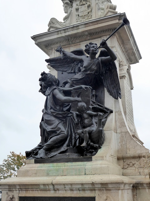
The statue of Champlain was created by the French sculptor Paul Chevré and dedicated on September 21, 1898. The statue depicts Champlain holding hat with a feather in his right hand and a roll of papers in his left hand. A bronze high relief on the front of the base has three allegorical figures. The woman is writing about the achievements and history of Quebec. To her right a child symbolizes the Genius of Navigation. At the top, an allegory of fame with outstretched wings is sounding a trumpet.


One side of the base is inscribed in English:

                   Samuel
                        De
                 Champlain

Born at Brouage in Saintonce
about 1567 _ Served in the French 
Army as Marechal des Locis
under Henri IV._ Explored the 
West Indies from 1599 to 1601 and also
Acadia from 1604 to 1607

Founded Quebec in 1608
Discovered the region of the Great 
lakes. Led several Expeditions
against Iroquois from 1609 to
1615. Was successively lieutenant 
Governor and Governor of New
France. Died at Quebec 25th Dbre 1635

The stamp was issued on June 1, 1935 as the high value of a set of 11 definitive stamps.

Philatelic Photograph: Château Frontenac - Quebec City, PQ, Canada

Château Frontenac 
Quebec City, PQ 
Canada


N 46° 48.704 W 071° 12.269


Quick Description: 

The Château Frontenac hotel is a prominent Quebec City landmark. It is located at 1, rue des Carrières, Quebec City, Quebec.


Long Description:

The Château Frontenac was build in seven stages from 1892 to 1893 by the Canadian Pacific Railway. It was was designed by American architect Bruce Price, as part of a series of château style hotels along the route of the Canadian Pacific Railroad during the late 19th and early 20th centuries. It is named after Louis de Buade, Count of Frontenac, the governor of the colony of New France from 1672 to 1682 and 1689 to 1698. In 2001, the hotel was sold for $185 million and renamed the Fairmont Le Château Frontenac.

The stamp was designed by Kosta Tsetsekas and based on an illustration by Heather Price. It depicts the Château Frontenac as viewed from the Dufferin Terrace. It was issued on June 14, 1993 as part of a series of five stamps depicting historic Canadian Pacific Railway hotels.